Temporal trends and spatial clustering

Address a range of global health issues in our online course Geo-Health

TEMPORAL TREND AND SPATIAL CLUSTERING OF CHOLERA EPIDEMIC IN KUMASI-GHANA

Osei, F.B., Stein, A. Temporal trend and spatial clustering of cholera epidemic in Kumasi-Ghana. Sci Rep 8, 17848 (2018). https://doi.org/10.1038/s41598-018-36029-4

Abstract

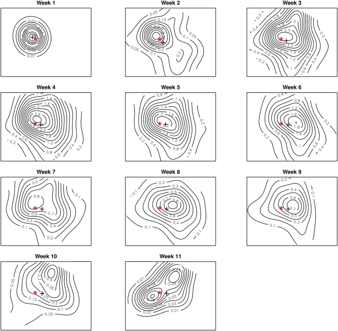
Knowledge of the temporal trends and spatial patterns will have significant implications for effective preparedness in future epidemics. Our objective was to investigate the temporal trends and the nature of the spatial interaction of cholera incidences, dwelling on an outbreak in the Kumasi Metropolis, Ghana. We developed generalized nonparametric and segmented regression models to describe the epidemic curve. We used the pair correlation function to describe the nature of spatial clustering parameters such as the maximum scale of interaction and the scale of maximal interaction. The epidemic rose suddenly to a peak with 40% daily increments of incidences. The decay, however, was slower with 5% daily reductions. Spatial interaction occurred within 1 km radius. Maximal interaction occurred within 0.3 km, suggesting a household level of interactions. Significant clustering during the first week suggests secondary transmissions sparked the outbreak. The nonparametric and segmented regression models, together with the pair correlation function, contribute to understanding the transmission dynamics. The issue of underreporting remains a challenge we seek to address in future. These findings, however, will have innovative implications for developing preventive measures during future epidemics.

For more information

Related courses

View all programmes
  • Geo-Health - 7EC (online course)

    Certificate10 weeks100% English
    Geohealth integrates spatial analysis methods and concepts with epidemiology to provide students with skills to address a variety of health and disease analyses.
  • Geo-information Science and Earth Observation

    Master of Science2 years100% English8 specialisations3 Joint programmes
    This Master’s teaches you to tackle some of mankind’s greatest challenges such as climate change, food and water security, land scarcity, and natural disasters by using geo-information data.

    8 specialisations for Geo-information Science and Earth Observation

    Applied Remote Sensing for Earth Sciences

    MSc2 Joint programmes
    In this specialisation, you will Iearn how use remote sensing and geographic information systems (GIS) to map supplies of critical raw materials and geothermal resources.

    Free specialization

    MSc2 Joint programmes
    Design your very own specialization

    Geo-Information Management for Land Administration

    MSc2 Joint programmes
    Learn to use cadastral intelligence for designing and applying responsible land administration solutions.

    Geoinformatics

    MSc2 Joint programmes
    Learn to develop technologies required for analyzing, distributing and visualizing geo-spatial data.

    Natural Hazards and Disaster Risk Reduction

    MSc2 Joint programmes
    Learn to predict and monitor multi-hazard risk and help reducing our vulnerability to disasters.

    Natural Resources Management

    MSc3 Joint programmes
    Learn to utilize geo-spatial data for sustainable agriculture, environement and forests.

    Urban Planning and Management

    MSc2 Joint programmes
    Learn to understand dynamic urban processes and create interventions to help make cities competitive, compact, sustainable, inclusive and resilient.

    Water Resources and Environmental Management

    MSc2 Joint programmes
    Learn to use earth observation and geo-information techniques to create safe and sustainable water management solutions.