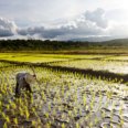
Population growth is leading to increasing demands for food and hence claiming more land for food production. This process has thrown many developing countries into a poverty trap characterized by expansion of agriculture into marginal lands, land degradation and declining yields. Programmes or projects that address these issues require timely and reliable (spatial) information on:
- Type and quality of available land resources.
- Management, productivity and sustainability of current and alternative agricultural land use systems.
- Effects of interventions and socio-economic conditions on land use and land cover modifications and conversions.
- Actual and anticipated (future) food demand and supply situations.
Major projects


Research
At ITC, we focus on fundamental and problem-solving research where spatial information can make a real difference.
Featured articles
Education
ITC is known to be one of the top institutes worldwide in the field of Geo-information science and earth observation. At ITC, we train students to engineer approaches for designing future-oriented solutions to the world's biggest challenges. We encourage our students to participate in public-private partnership projects initiated by ITC and other organizations.