Over the years, ITC has developed its expertise in the field of various knowledge domains.
 4D-EARTH
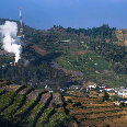
Combine earth science knowledge with spatial modelling and advanced earth observation analysis, to improve our understanding of the impact of climate and population change on the scarceness of resources and energy, changing natural hazards and increased vulnerability and risk of our society.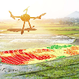 Acquisition and quality of geo-spatial information
Developments in sensor and web technology have led to a vast increase in earth observation data. Advanced methodology is needed for interpretation and integration of such big geo-data to support decision making.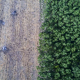 Forest agriculture and environment in the spatial sciences
In FORAGES research we use earth observation data and spatial information in combination with systems modeling, geo-information science and remote sensing for the assessment, monitoring, planning and management of natural resources, for their sustainable use, development and restoration.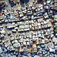 People, land and urban systems
PLUS focuses on understanding the spatial information needs of society and responding to those needs in responsible ways – as tools, as systems, as infrastructure, or as ways of thinking. Our work sits at the nexus of urbanization, land tenure, governance, climate change, and transportation – and the grand challenges of sustainability and social equity in the age of the anthropocene.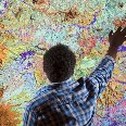 Spatio-temporal analytics, maps and processing
Our objective is to develop methods and techniques that process (organize, model, analyse, and visualize) spatio-temporal data into valuable and accessible geo-information and tools that improves our understanding of complex and dynamic systems and helps in decision-making at a variety of spatial and temporal scales.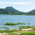 Water cycle and climate
Water, food and energy security and environmental safety are key challenges to our societies. “Information on water quantity and quality and their variation is urgently needed for national policies and management strategies, as well as for UN conventions on climate and sustainable development, and the achievement of the Millennium Goals”.