| Student: | M. Li |
|---|---|
| Timeline: | December 2017 - 4 December 2021 |
| Sources of funding: | ITC / ITC Fellowship Fund |
Abstract
The Tibetan Plateau, as the highest plateau in the world, plays a prominent role in the evolution of the Asian hydrological and ecological system. Many major Asian rivers originate from the Tibetan Plateau and adjacent mountain ranges feeding more than 1.4 billion people. Groundwater is an important source of streamflow in headwater areas. It is constrained by recharge, aquifer permeability or transmissivity, aquifer storage, and groundwater quality. In groundwater modeling, which is often used to manage regional groundwater resources, the estimation errors are always dominated by incorrect parameter values. Parameters are conventionally calculated from pumping test, which means a number of wells must exist or be drilled, which is expensive. Since parameters are spatially heterogeneous, and field measurements are limited in most cases, it is difficult to get a precise distribution of subsurface parameters.
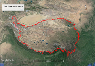
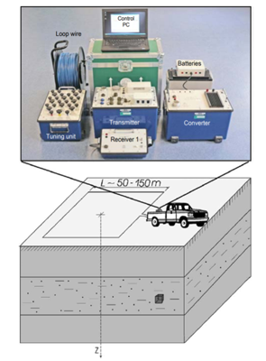
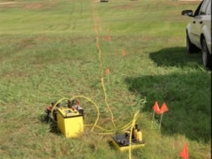
The aim of this study is to retrieve subsurace parameters using data assimilation techniques based on satellite measurements, in-situ measurements and an integrated hydrological model (IHM) in a Tibetan plateau catchment. The catchment is located in Maqu country at the eastern edge of the Tibetan Plateau with little data available. In order to set up the IHM, the hydrogeophysical and the landscape evolution models will be first employed to create a conceptual model in the study area. The hydrogeophysical model will be based mainly on Magnetic Resonance Sounding and Electrical Resistivity Tomography techniques while landscape evolution model on LAPSUS model and soil sampling. Once the IHM is set up, data assimilation techniques will be applied to assimilate satellite measurements, e.g. soil moisture and temperature, and some in-situ measurements, e.g. groundwater levels, to estimate parameters, e.g. hydraulic conductivity and transmissivity. Pumping/slug tests will be conducted in the study area to verify the estimated parameters.
Meet the team