As a result of climate change, extreme droughts are expected to occur more often in the Netherlands, potentially causing social distress and huge economic damages.
The WUNDER project will develop an integrated modeling system for understanding the behaviour of soil and vegetation during prolonged drought events. The system will enable to explore scenarios and evaluate strategies for managing, planning and adapting agriculture and nature systems to extreme droughts. The project will actively engage with farmers, water managers and other decision makers and develop practical use cases for daily drought monitoring and prediction, thereby supporting climate-robust production systems and water management.
The WUNDER consortium is designed as a collaborative as a whole in order to effectively exploit existing and develop new knowledge at the local to national scale by addressing three scientific challenges (WP1-3) related to drought events that are projected to increase due to climate change. We do so by conducting field measurements and develop integrated modeling tools for different agriculture and nature systems (WP1) and combining these data with satellite observations to scale the gained knowledge and tools up to national level (WP2, WP3) for timely and effective agricultural and water management from farm to national scale via two innovative applications (WP4, WP5). We have coherently co-designed, together with our stakeholders, five interlinked work packages (see Figure 1) to address the three major scientific challenges and the two innovative applications (as corresponding to five hypotheses).
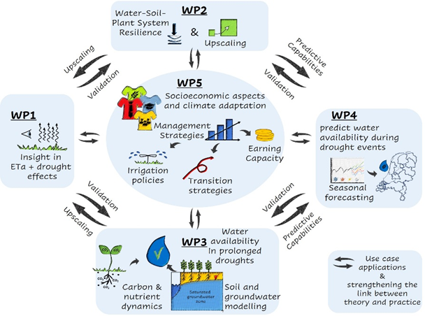
Figure 1 Coherence and synergy of the integrated WUNDER system and the WPs
Workpackages
Find out more about the subjects.