| Student: | L.M. Prieto Leon (Lydia Marleny) |
|---|---|
| Timeline: | August 2014 - 30 September 2019 |
This research evaluates school admission strategies from a decision making perspective. Part of the education policy of the US government is the school choice plan. In such a plan, families express preferences over the schools their children want to attend. However, it is not always possible to assign each student to their first preference school, because school districts are also facing priorities set up by local policy-makers and assign children to schools according to some objectives, targeting a desired balance across race, socio-economic background, and/or ability dimensions across schools.
There is evidence that the geographical location is a key factor for understanding the impact of choice in the school system. However, the geography of education provision and the interactions with differences in spatial patterns of educational demand and the socio-economic characteristics of students and their families need to be further studied. The focus of most research is on either supply or demand, or on matching, but not on integrating those. The interrelations between these three components, supply, demand and matching, have not yet been fully analyzed. Research focuses on models that allow enrollment simulations and multiple scenario comparison, however most of these models show results using numbers and text, difficult to understand by planners. Existing models that support school choice neither allow users to interact with the system, nor allow intuitive exploration and changes in weights and impacts of the alternatives.
The main goal of this research is to understand how the suitability of different school admission strategies can be evaluated, by incorporating student and school preferences, in the context of a decision making framework. Through the analysis of school choice in magnet elementary schools in one large School District in Florida, USA, this research aims to design a Multi-criteria Decision Support System (MDSS) for student placement. This MDSS will deliver an easy visualization, analysis and exploration of data and provide insights into the design of student placements strategies.
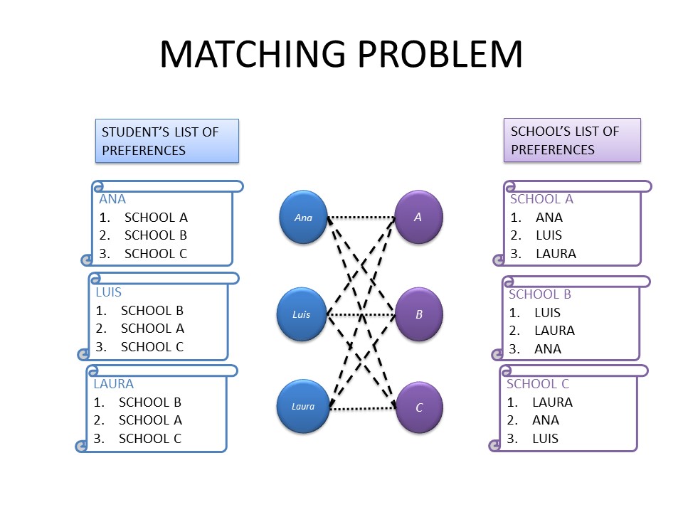
In order to achieve this, there are four specific objectives to be addressed. First, the demand for school locations is measured by deriving the utility values of each student from a Multinomial Logit Discrete Choice Model (MNL) that takes into account capacity constraints and a given school network configuration. Second, school’s preferences are examined by analyzing the impact and suitability of selecting one student to a school using a multi-criteria decision model (MCDM). Schools have a number of available seats and they rank-order applicants according to specific priority criteria that reflects the district’s policies. Third, the mechanism for assigning students to schools is proposed, by building on the algorithm introduced by Gale and Shapley. A second MCDM is formulated, that puts together supply, demand and matching. The last objective embraces the design of a Geo-visual analytics framework for easy visualization, analysis and exploration of data, which provide insights into spatial interactions, geo-visual analysis and scenario comparison.
This research integrates policy, methods and models that might be beneficial for supporting school planners in designing effective educational policy, as well as providing accessibility, transparency and equality to families.
Keywords: school choice, decision support system, student placement, geo-visual analytics, choice modeling, MNL model, MCDM, multi-criteria model.
Meet the team