| Student: | S. Alvarado Vazquez |
|---|---|
| Timeline: | October 2018 - 1 October 2022 |
| Sources of funding: | CONACYT, Mexico |
The participatory planning processes and its relation with the inclusive involvement of the people in the city it is a practice that has been left aside by local governments in Latin America; the Information available for urban communities related to urban issues, specially in public spaces is practically non-existent in many Latin American cities and specifically in Mexico.
Only few cases, usually middle-upper class neighborhoods, had the necessary knowledge about the situation in the place where they live, usually solving basic infrastructure problems by their own resources, like maintenance of green areas or the development of communal areas.
But unfortunately, not everyone has the same knowledge about what people can do in their context. This is more predominant in low income or segregated areas of Latin American cities, usually the efforts to improve the infrastructure of a neighborhood are led by the local government, but without the inclusion of the society. The possibility of generate urban knowledge for them is almost made for a few NGO´s trying to show these communities the benefits of better public spaces and how to get them, but still there is a lack of information regarding to the urban spaces and how they can be participants in the process.
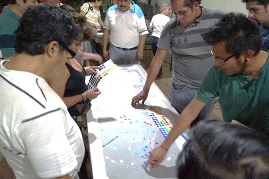
Therefore, this research is more focused on the process of developing participatory methodologies that would be providing accurate information through collective mapping data for local urban communities. The gathered information would help to create an open access tool where communities could understand their needs in order to rehabilitate or create public spaces that could meet their needs and also empowering them in order to be more active in their urban situation.
Currently in Latin America and specifically in Mexico, real estate speculation and the expropriation and sale of public lands to private sector, generates the dispossession of properties that should have a public use. The proposed objective at this moment, is to develop a methodological tool that would be able to show why it is important to maintain, conserve, rehabilitate or appropriate public spaces in rural/urban communities through the collective knowledge of the inhabitants and using technological tools. This could be achieved through the use of supporting technologies such as Participatory Geographic Information systems (GIS), participatory methodologies and perhaps the virtual immersion on the project with VR technology for a more dynamic process with communities. The hypothesis is to know if through the use of new participatory technologies and other support systems, the social inclusion in the urban planning process of public spaces could improve the decision making of new infrastructures.
Meet the team