| Student: | C. Duan |
|---|---|
| Timeline: | October 2021 - 1 October 2025 |
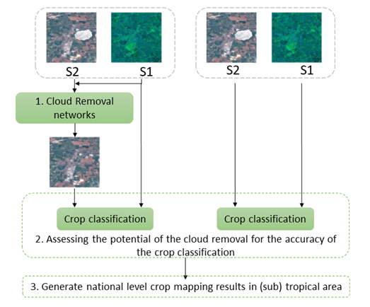
Cloud cover is an inherent feature of optical remote sensing imagery, often leading to the acquisition of erroneous or incomplete data. Given its potential to hinder subsequent image processing and utilization, the reconstruction of cloud-obscured information becomes imperative. Although the majority of the cloud-free results can be successfully applied in visual effect-oriented tasks (e.g. geographical mapping), its utility diminishes when accurate physical attribute-oriented tasks such as classification are considered. As the presence of clouds significantly impacts crop mapping, we aim to address cloud removal for crop classification, since crop mapping is essential for food security and agricultural management. We aim to develop SAR-optical image fusion networks that remove cloud cover from optical images using comparatively lower computational resources. Using deep learning must result in efficient and effective cloud removal networks that could process time series of images for crop classification tasks within a relatively small amount of time and little memory use.
To realize the objective of efficient and accurate crop mapping, we outline the following strategies:
- Development of computationally efficient cloud removal networks.
- Evaluation of the efficacy of cloud removal in enhancing crop mapping accuracies.
- Completion of national-level crop mapping endeavors in (sub)tropical regions afflicted by cloud cover.
Meet the team