| Student: | G. Anjanappa |
|---|---|
| Timeline: | April 2023 - 15 April 2027 |
Topographic maps are abstractions of the real world showcasing the spatial arrangement of various objects and landscapes. In the Netherlands, many government agencies use Basisregisteratie Grootschalige Topografie (BGT) maps for urban planning, water management, and other purposes. However, these maps can quickly become outdated due to the constant environmental changes. At present, different agencies manually update the BGT maps, leading to prolonged processing periods. With recent developments in deep learning (DL), many methods have automated change detection using multi-temporal geospatial data to obtain "from-to" changes. In principle, existing digital maps can offer valuable ground-truth data. However, their potential as a baseline for detecting changes remains underexplored.
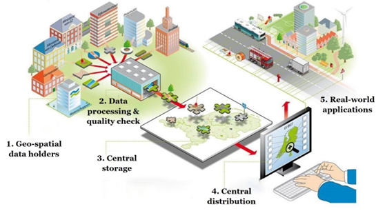
Figure 1: Flow of geospatial data through BGT maps from source to central facilities and finally to the users for real-world applications. (Source: Author and image from Geonovum)
In this context, the current research is part of an umbrella project aiming to automate updating BGT maps of the Netherlands. This Ph.D. research focuses on detecting semantically meaningful changes that provide "from-to" information using existing maps and newly acquired airborne data. Utilizing BGT maps and 2D-3D airborne data from the Dutch agencies Beeldmateriaal and Actueel Hoogtebestand Nederland (AHN) is central to this effort. Additionally, the research aims to examine the potential of applying this change detection methodology in disaster management scenarios. The goal is to refine the designed approach further to support automatic change detection across different international contexts in post-disaster evaluations.
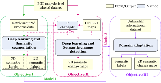
Figure 2: Overall research framework illustrated in the context of three identified objectives represented individually and collectively concerning each other. Objectives I, II, and III workflows use green, pink, and purple colours.
Keywords: BGT map, airborne data, deep learning, multi-modal semantic segmentation, 2D-3D fusion, change detection
Meet the team