| Student: | L. Trento Oliveira MSc |
|---|---|
| Timeline: | March 2023 - 1 March 2027 |
Slum settlements are marked by urban poverty, inadequate housing and poor infrastructure and services and they are one of biggest contemporary urban challenges. These settlements have been growing in many Sub-Saharan African (SSA) countries and the projections indicate the trend will remain and will mainly occur in smaller secondary – understudied - cities. While much effort has been done to acknowledge and track slum settlements, the understanding related to their climate vulnerability is still insufficient. This is particularly alarming considering the acute impacts of climate change in SSA: Exposure to high-frequency flooding is projected to increase by 2600% across west, central and east Africa by 2030 (IPCC, 2022). In the meantime, 60% of the Sub-Saharan African (SSA) urban population lives in slums currently facing life threatening impacts. Nevertheless, despite the consensus that the growing worldwide trend of disasters has significant impacts in slums, they remain untargeted in most urban flood risk studies and consequently risk policies.
The challenges to surpass this gap are twofold: (1) risk and vulnerability studies often resort to Earth Observation (EO) data to derive environmental information and census data to derive socioeconomic information but in African context, census surveys are often temporally and spatially inconsistent, especially for slum areas. (2) recent studies are resorting to Citizen Science (CS) data to address this gap, mostly using mostly crowdsourcing initiatives through data collection. Though important, those efforts have been moving citizens closer to the role of instruments of data collection, without including them throughout the research process and as beneficiaries of the research outcomes. This perpetuates the typical narrative of exclusion where only official authorities produce and retain all the risk-related information, creating top-down decisions with little acceptance of local stakeholders.
Based on this, this research´s goal is to this research aims at developing and testing collaborative methodologies that combines CS and EO data and technologies to support flood risk and vulnerability mapping of slums in SSA cities. More than acquiring data, we want to understand risk and vulnerability through the local lenses and ensure our project is relevant to improve the living condition of the residents.
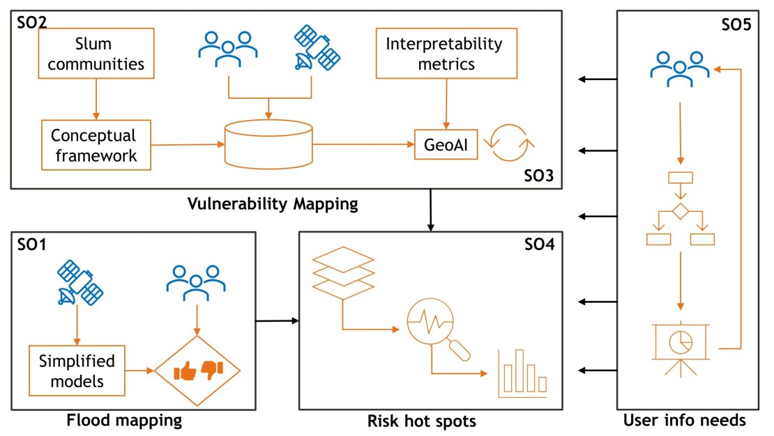
Research Framework with Sub-Objectives
The operationalization of this research will initially take place in Nairobi and Kisumu (Kenya), and I will strive to replicate the methodologies in Ghana (Accra and Tema) and Nigeria (Lagos and Akure). I propose five sub-objectives: : (1) to test the performance of simplified flood models and globally available data to map flood events in slum contexts and locally optimising and validating the outputs with stakeholders; (2) to co-design a conceptual framework with local stakeholders to conceptualise urban flood vulnerability that is relevant for slum contexts using CS and EO data; (3) to apply this framework and assess the interpretability of the proposed EO- and CS-based indicators; (4) to analyse the resulting flood risk hotspots, i.e., to locate the most vulnerable groups across and within each study area; and, finally, (5) to identify the information needs and preferences of slum residents regarding risk and vulnerability assessments and translate them into communication and visualization strategies.
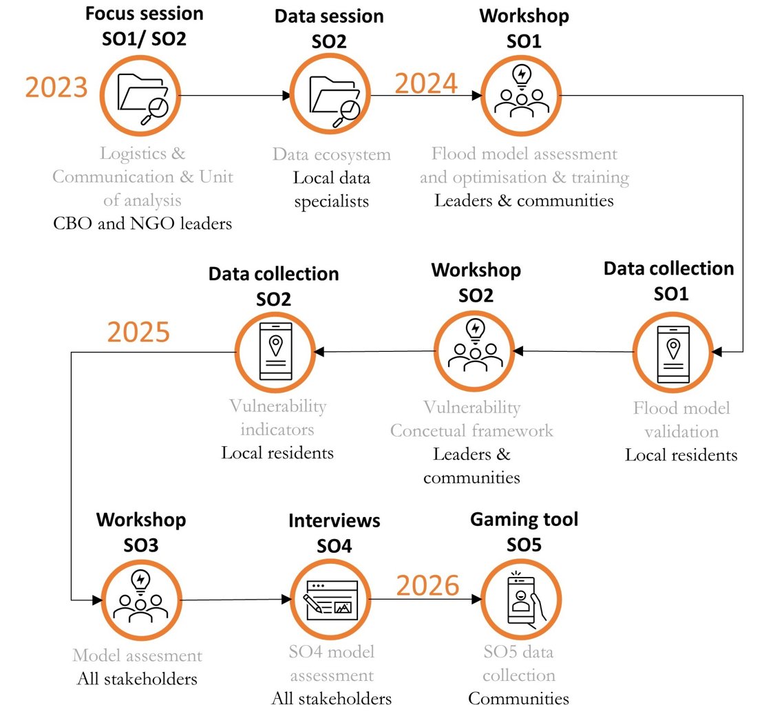
Roadmap of Collaborative Methodologies
The findings of this research are expected to inform cross-disciplinary research in terms of methods and datasets in typically data poor environments. The most significant contribution is to provide evidence on flood risk and vulnerabilities of slum communities by leveraging CS practices into geospatial methods. Local knowledge will be incorporated beyond the data collection, promoting local stakeholders as co-creators of the research itself. Given the transferable nature of the approach, the collaborative methodologies could be reproducible to other SSA cities facing floodings and the emergence of slum settlements.
Meet the team