Gain in-depth expertise in the technology behind Earth Observation and GIS to solve global challenges.
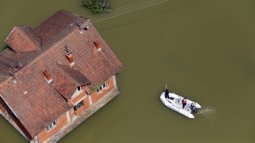
How do we monitor climate change from space? How can Geo-AI predict water shortages or map disaster-stricken areas in real-time? We live in a digital society where Geo-AI and Earth Observation are vital for managing a sustainable planet. This is the ‘science of where’: understanding exactly where changes occur, where stakeholders are affected, and where solutions will be most effective. Whether it is creating disaster-resilient solutions, planning smart cities, or monitoring the Earth’s resources, the ability to generate real-time spatial insights is essential for our changing environment. In this Master's, you develop the expertise to engineer the methods that make these insights possible.
Building on the world-leading reputation of the ITC Faculty, you will dive deep into the scientific and technical methods used to capture, process, and visualise spatial data. You will master the full data cycle - from high-end acquisition using satellites, drones, and sensors to the development of advanced algorithms and spatial models. As a student, you learn to transform raw data into the actionable geographic information needed to support sustainable development worldwide.
Choose a specialisation
You have a lot of freedom to tailor your Master’s in Geo-Information Science & Earth Observation to your interests and ambitions. You will build your own expertise within one of the seven specialisations, which represent different domains of the geospatial field. You can choose one of the following specialisations:


Career perspectives
Obtaining this Master's degree, you become part of a world-renowned network of geo-information professionals. Our graduates are highly sought after for their ability to bridge the gap between complex spatial technology and real-world decision-making. You will be equipped for a career at the forefront of the geo-information sector, working in roles such as Spatial Data Scientist, Remote Sensing Expert, or GIS Systems Architect.
The global demand for GIS experts is growing rapidly. Our alumni find their way to prestigious international organisations such as the United Nations (UN), the World Bank, and the European Space Agency (ESA). Furthermore, you will be prepared for key roles in national mapping agencies, environmental consultancies, and the private sector, where tech giants and engineering firms rely on spatial data to build a sustainable future. Whether you pursue a career in research, policy-making, or technical development, your expertise will be instrumental in solving the global challenges of tomorrow.
Related master’s
Not sure if this Master’s is exactly what you’re looking for? Maybe another related master’s at the University of Twente suits you better:
- Master's in Sustainable Energy Technology
- Master's in Geo-information Science and Earth Observation
- Master's in Humanitarian Engineering
Which Master's fits you better?
If you’re interested in geospatial science, Faculty ITC offers two strong Master’s programmes: Geo‑information Science & Earth Observation and Spatial Systems & Society. They overlap, but they prepare you for different kinds of careers and ways of working.