| Student: | L.N.N. Wandera (Loise Nancy Nangira) |
|---|---|
| Timeline: | June 2014 - 1 November 2018 |
Wetlands are continuously receiving recognition for their high biodiversity and for their important hydrological functions in groundwater recharge, nutrient cycling and flood alleviation. Hence these are important ecosystems that not only impact the regional hydrological cycle but also the surrounding ecological communities. Many of the world's wetlands are continuously facing threats either from direct effects of prevailing human activities or the current impacts of the changing climate. The overall result is variation in wetlands’ typical hydrological properties degradation of vegetation and peat soils. Hence, integrated decision support systems for wetland conservation need to be developed and should aim at maintaining a balance between processes involved in total water budget (precipitation, evapotranspiration, and runoff).
Evapotranspiration (ET) (or latent heat flux, λE) is a major element of the wetlands’ water budget which appears to have been surprisingly overlooked. The majority of the wetland hydrological studies have particularly been focused on quantifying the precipitation aspect of water cycle i.e. discharge characterization and flow path determinations. Attempts put towards determining ET have often quantified it only as part of a lumped term included within other retrieved water-budget components and in some cases over simplified. In the context of climate variability, we are obliged to develop a better understanding of ET because according to studies, wetlands surface energy and water fluctuations will exhibit major anomaly due to expected changes in land surface temperature (TR) and associated radiative forcing over the coming years. As a consequence, energy and water balance aspects within the wetlands will be more affected because wetlands typically dissipate higher energy levels through ET compared to other terrestrial ecosystems that is a physiological adaptation mechanism to their environment. Whereas the balance between water and energy plays a fundamental role in the maintenance of wetland functionality, it is urgent to (1) synthesize available observations and experiments relevant to understanding surface energy balance process in wetlands (2) characterize possible feedbacks between wetland ecosystems and climate.
Remote sensing based approach is perhaps the only feasible method for projecting ET in large scale. This is not to disregard ground based methods which have undergone significant improvements over the years e.g. micrometeorological flux towers and Bowen ratio stations. Ground based measurements recently are being used to compliment both empirical and physical techniques used in remote sensing of ET at plot scales and also in the advanced platforms with higher spatial and temporal coverage.
This PhD research will aim at characterizing the evapotranspiration in wetlands and particularly focus on 'Multi-scale Surface Energy Balance modelling for wetland ecosystems' using dedicated thermal satellite based remote sensing models that apply deterministic and prognostic approaches (SEBS, STIC and SCOPE). The research will be divided into:
- Parameterizing two diagnostic and one prognostic thermal remote sensing driven ET models for chosen wetland sites Figure1
- Evaluate the model outputs against eddy-covariance measurements
The research is expected to:
- Establish long-term changes in wetland evaporative depletion
- Quantify the ecophysiological controls on wetland ET dynamics
- Develop time series consistent ET records over the wetlands
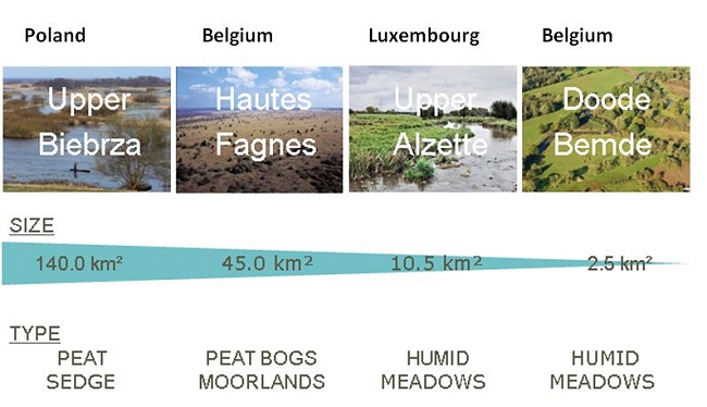
Figure 1
Meet the team