| Student: | Marieke L. Laengner |
|---|---|
| Timeline: | March 2018 - 12 March 2022 |
Abstract
Saltmarshes are located in marine, intertidal zones between land and sea. They are highly productive ecosystems and provide several crucial ecosystem services. Many fish and birds use these ecosystems as a hiding place from predators, for resting, feeding and breeding. Furthermore, they provide recreational areas, improve water quality, and reduce the risk for coastal population from being flooded by reducing current and wave energy, allow deposition of delivered sediments, and stabilizing the shoreline. Especially this funciton as barrier between land and sea becomes increasingly important for humankind with the combination of accelerated sea level rise (SLR), increasing intensity of storm surges, and growing coastal population. At the same time, saltmarshes are threatened by climate and environmental change and direct human impact.
Many studies have been done already on saltmarshes and their vulnerability to environmental change and relative SLR. Nevertheless, most findings from empirical studies or theorectical models cover only site-specific environmental and intrinsic conditions or do not take into account all drivers causing saltmarsh habitat change. This makes it challenging to draw conclusions on saltmarsh vulnerability, as saltmarsh characteristics vary among different locations and saltmarsh dynamicsw depend on various (combinations of) intrinsic and environmental biophysical variables. Consequently, efforts to generalize saltmarsh vulerability led to contrasting conclusions. Consequently, there is a need for large-scale, longtermassessments of saltmarsh dynamics and their vulnerability to fluctuating intrinsic and environmental biophysical variables.
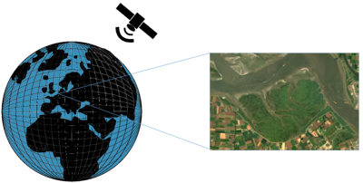
Satellite remote sensing techniques make this apporach feasible as satellites provided global continuous data over long time periods. These techiques can detect actual habitat change and with this completeestimates from theretical modeling and emporical, site-specific studies. A huge amoount of remotely sensed data are available with different spectral, spatial, and temporal resolutions. In order to benefit from the growing amount of data, automated procedures to process and analyze these are necessary. Methods to use earth observation data in order to produce long land cover time series over a large area are increasingly produced and improved towards automatization.
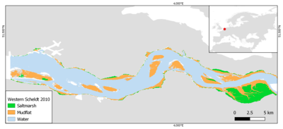
Considering existing methods for saltmarsh habitat observation and the possibilities to make use of the growing amount of satellite data, the main goal in this paper was to develop an automatic saltmarsh classificaiton procedure and with this analyze habitat change of European saltmarshes ove a time period of 27 years (1985 to 2011). The ability to derive saltmarsh habitat change automatically provides a powerful basis for comprehensive analysis of saltmarsh dynamics. It enables us to cover different saltmarsh types, include replicates, and identify main drivers causing saltmarsh expansion or retreat.
In order to better understand dynamics, we use satellite images to create a powerful data basis of habitat change, which can be linked to changes of intrinsic and environmental biophysical variables (e.g. tidal range, sediment concentration, relative SLR). Based on this, we aim to build a model to project longterm dynamics under changing environmental conditions.
Meet the team