| Student: | L. R. Morales Ortega MSc |
|---|---|
| Timeline: | December 2023 - 30 November 2025 |
Context and motivation
Globally, groundwater is under increasing pressure due to climate change, population growth, and urbanization. Many regions are experiencing groundwater depletion, pollution, or flooding because of extreme weather. Climate change is intensifying hydrological extremes, producing longer droughts and heavier rainfall events. Cities especially struggle to balance flood prevention and water availability, since infrastructure wasn’t designed for such volatility.
Moreover, in The Netherlands, long-term KNMI (2025) data confirms that annual rainfall is increasing, reaching high records (e.g., 2023). Yet, dry periods are becoming more frequent and severe (1996, 2003, 2018, 2025). These extremes put pressure on urban groundwater systems, making both flooding and drought-related complications more likely. Therefore, in response to the extreme droughts, rainfalls and the drainage challenges, the Enschede Municipality (EMUN) has committed to becoming greener and bluer by 2050 (Gemeente Enschede, 2021), aiming to evolve into a climate resilient, water robust, and biodiverse city.
Within the Enschede Municipality, hard surfaces are being replaced with vegetation, new areas such as green spaces are designed to absorb and temporarily store rainwater, and controllable smarter drainage systems are being installed in specific spots around the city. These measures aim to make the city’s surface behave like a sponge, storing water locally during rainfall and releasing it gradually during droughts. Achieving this vision requires accurate and reliable, near-real-time insights into groundwater dynamics, which motivates the development of a Digital Twin (DT) to monitor and control groundwater levels proactively.
The concept of a DT is defined as a digital representation of a physical element capable of reflecting, predicting, and influencing the real world processes. According to Fuller et al. (2020), a DT is a virtual replica of a physical object, system, or process that monitors, simulates, and optimizes its real counterpart through past, present, and future states. The Minimal Interoperability Mechanism MIM8 standard further defines DTs as digital representations of physical assets or processes in a local context, that can enable visualization, analysis, simulation, and decision making through real-time or historical data integration. Unlike conventional digital models, DTs retain a bidirectional link between the physical and virtual environments (Digital Twin Geohub, 2022), enabling observation and even prescription of actions.
Findings in previous research (Morales, L. R., 2023), highlighted the potential of integrating Digital Twins for dynamic groundwater management based on the groundwater table (GWT) behavior and how DTs in hydrology should not be limited to passive monitoring. Likewise, the study identified potential interactions for flood and drought simulations and how DTs can bridge the digital and physical systems with relative low investment, paving the way for further exploration and development. Even though, the results of the previous research led to positive findings, the previous DT had limitations related to data collection, prediction model reliability, physical implementation, programming optimization, interface for visualization and water management decision making.
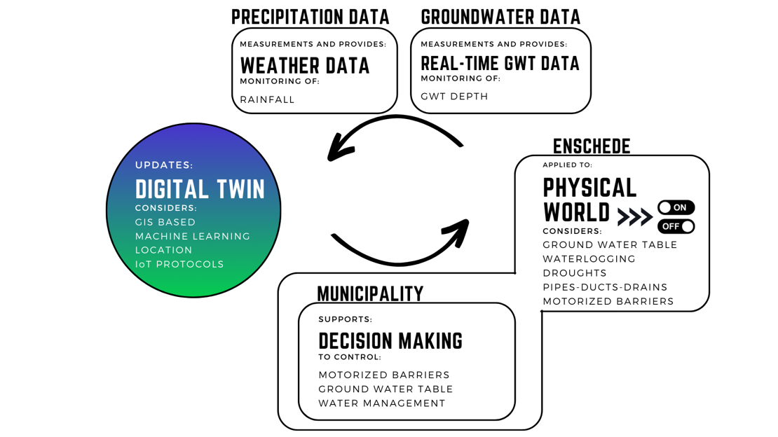
To address these shortcomings, in this engineering doctorate (EngD) project, a groundwater table (GWT) management DT prototype was developed for EMUN to support data driven and predictive water management. The system integrates near-real-time sensor data, GWT forecasts, and controllable barrier mechanisms within a drainage system to regulate groundwater retention and discharge. Through this setup, water experts can visualize and anticipate changes in the groundwater levels and act proactively, by draining or retaining groundwater depending on expected weather conditions, through Internet of Things (IoT) actuators connected to the city’s drainage infrastructure.
Conceptual design summary
The conceptual design of the DT follows an integrated, modular workflow that operates through a continuous loop of data acquisition, prediction, analysis, and visualization. The process begins with a connection module that authenticates user credentials to access rainfall data and ArcGIS Online resources. The retrieved data are standardized in the pre-processing module before entering the prediction module, where future groundwater levels are estimated based on rainfall and drought patterns. These forecasts feed into an analysis module that applies a physical drainage model and municipal groundwater thresholds to determine the suggested actions per case, such as the openness percentage to which barriers should open or close, in order to maintain optimal groundwater levels.
The visualization and decision support modules present the analyses through an ArcGIS based dashboard that displays a map, graphs, and status messages with color coded indicators, allowing water experts to review the predictions, validate the suggestions, and access log files for transparency and traceability.
Moreover, an optional actuator control module connects the DT’s predicted results to a 3D barrier simulation, that showcases how the real-time control could be implemented in future field deployments. Although automation is technically feasible, the final decision remains with municipal water experts, ensuring supervision from the ethical and environmental points of view in managing groundwater levels.
However, the predictive capabilities of the DT remain basic, as the employed model to predict GWT levels, was trained with one year data in a short time frame of past rainfall and GWT levels to predict 1 hour of GWT ahead. Therefore, the prediction model was designed as a proof-of-concept to test the feasibility of forecasting future GWT levels with fewer input variables than conventional methods (e.g., soil porosity, humidity, temperature, drainage slope). Additionally, a modular system was implemented to allow future, more accurate predictive models to be easily swapped without disrupting the DT architecture, enabling future improvement and scalability.
Contribution:
The value of this technology lies in its potential to reduce manual calculations, enhance decision making, and improve climate resilience in groundwater management. By providing near-real-time insights into GWT fluctuations and linking them to control actions, the DT supports EMUN’s “greener and bluer city” initiative by balancing water storage and drainage to prevent both flooding and drought.
The complete DT workflow was evaluated collaboratively with EMUN staff through feedback sessions, which evaluated integration with EMUN’s workflow, ranging from user interaction, prediction model confidence, to notification clarity/validity, prototype efficiency, and decision support usefulness. The DT’s GWT predictive performance was also quantitatively assessed using a train-test split, which showed that the Convolutional Neural Network (CNN) based model explains 99.37% of the variance in groundwater levels. Moreover, complementary evaluations helped verify that the predictions follow a physical coherent GWT behavior and closely match the true GWT measurements. Additionally, the DT was fully migrated to EMUN’s servers to run performance testing and validate the compatibility with EMUN’s work environment and future system scalability.
Overall, the project showcased the technical feasibility of integrating continuous sensor data, predictive modeling, and actuation in a single DT. Its modular architecture allows the DT to easily replace or upgrade its predictive models, sensors, or actuators without disrupting the system and the successful connection of the digital predictions with physical responses.
Performance tests further showed that the framework can run on standard municipal computers, facilitating accessibility, scalability, and adoption within EMUN’s water management strategy.
References
Digital Twin Geohub. (2022). Digital twinning for urban and rural environmental modelling. University of Twente. Retrieved from https://www.itc.nl/about-itc/centres-of-expertise/digital-twin-geohub/
Fuller, A., Fan, Z., Day, C., & Barlow, C. (2020). Digital twin: Enabling technologies, challenges and open research. IEEE Access, 8, 108952–108971. https://doi.org/10.1109/ACCESS.2020.2998358
Gemeente Enschede. (2021, October 21). Enschede wordt ‘groener’ en ‘blauwer’. GroenBlauw Enschede. https://groenblauwenschede.nl/bewoners/nieuws/enschede-wordt-groeneren-blauwer/
KNMI, (2025). Climate Dashboard. https://www.knmi.nl/klimaatdashboard. Accessed May 30, 2025.
(MIM8) Open & Agile Smart Cities. (2022). Minimal Interoperability Mechanisms (MIM) 8: Local Digital Twins (Version 1.0). OASC.
Morales, L. R. (2023). A Digital Twin Model for Groundwater Table Monitoring [Master’s thesis, University of Twente]. UT Student Theses Repository. https://purl.utwente.nl/essays/97168

Meet the team