| Student: | A. Ali PhD |
|---|---|
| Timeline: | February 2025 - 15 February 2029 |
The main objective of this research lies in the development of an AI-driven framework for predictive urban growth modelling by integrating the results from temporal change detection of land cover, the environmental effects, and environment-centric predictive modelling within Dubai, UAE using high resolution satellite imagery. This framework will enable decision-makers at Dubai Municipality to plan interventions related to urban growth with a focus on the environment. It will also ensure that planners can access and interact with environmental and spatial data via well-defined framework with clear data input and output pipelines.
Recently, AI models have demonstrated strong performance in semantic segmentation tasks and by applying these models to multi-temporal high-resolution imagery, urban changes can be detected and mapped. This research responds to the benchmarking and comparison of traditional change detection methods with AI-driven deep learning models and hybrid approaches in arid environments like Dubai. Hybrid approach is a combination of using traditional and AI based models to provide results on a complex and modern urban growth areas.
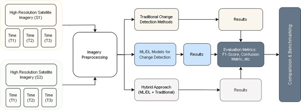
Figure 1: Comparison Workflow for Urban Growth Change Detection
The environmental changes due to urban expansion are a central concern of this research. By quantifying satellite data driven indicators such as vegetation change, carbon sequestration, desertification and surface temperature, this study provides insights into how land cover changes affect ecosystem health. These outputs studied with the urban growth patterns can provide vital information for climate mitigation strategies and contribute to sustainability goals of any municipality.
Building on these environmental assessments, the research integrates predictive modelling to anticipate future urban expansion and its potential ecological consequences. Predictive modelling is an essential component of the proposed research. Using AI techniques such as sequence-based learning and temporal spatial analysis, the study develops models capable of forecasting urban expansion trends. These forecasts will support proactive planning, allowing municipal authorities to anticipate infrastructural needs and mitigate potential environmental impacts before they occur.
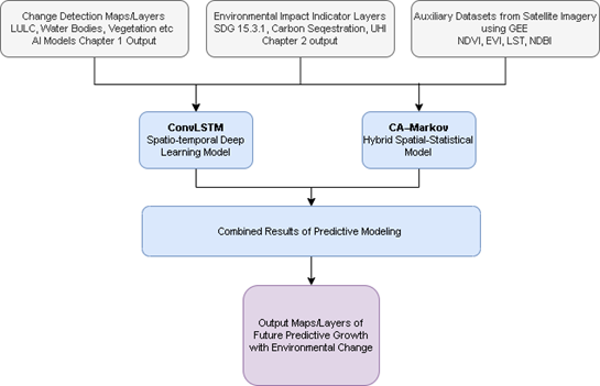
Figure 2: Workflow for AI Predictive Modelling
This research addresses the following sub-objectives:
- Sub-Objective 1 establishes a benchmarking and comparison of AI-based, traditional and hybrid change detection methods using Dubai-specific satellite data.
- Sub-Objective 2 focuses on quantifying environmental effects analysis such as vegetation loss, land degradation, urban heat island, desertification and carbon sequestration.
- Sub-Objective 3 involves predictive modelling to forecast urban growth patterns, aiding strategic foresight.
- Sub-Objective 4 proposes scalable AI integration with GIS dashboards to support continuous, evidence-based decision-making for municipal planning departments.
This research advances the scientific understanding of accurate urban change detection and directly supports the operational needs of a modern municipality. To ensure the practical relevance and policy integration of this research for urban decision-makers and academic stakeholders, a formal relationship has already been built and is reinforced by Dubai Municipality’s formal endorsement of the study.

Meet the team