Noise pollution is an increasingly urgent issue in urban environments, affecting public health, quality of life, and environmental well-being. In response, researchers at the Faculty of Geo-Information Science and Earth Observation (ITC) at the University of Twente have developed an innovative tool: OGITO – the Open Geo-spatial Interactive Tool. This interactive, map-based platform is designed to support collaborative urban planning by making complex spatial data accessible and actionable for a wide range of stakeholders.
This is a summary of an article on The Fraunhofer Innovation Platform website. Read the original article here.
A human-centred design approach
OGITO was developed with a clear mission: to empower communities and decision-makers to understand better and address noise-related challenges in cities. What sets OGITO apart is its human-centred design approach, which places users at the heart of the development process. Through workshops, interviews, and co-design sessions, ITC researchers worked closely with residents, GIS experts, urban planners, and software developers to ensure the tool is both intuitive and effective.
The tool is built around a maptable interface, a large touchscreen that displays geospatial data in a user-friendly format. This allows participants—regardless of technical background—to interact with maps, identify noise sources, mark affected areas, and explore potential interventions. OGITO’s interface was refined using the ISO usability framework, ensuring that even first-time users can navigate the tool without assistance.
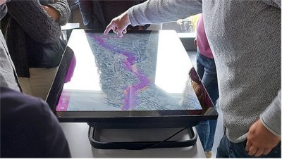
OGITO-noise used during the NAP workshop in Bochum
Pilots in Indonesia and Germany
The first version of OGITO was piloted in Sumatra, Indonesia, where residents of Denai Lama and Kramat Gajah contributed to the tool’s development. Their input helped shape a lightweight, simplified application that meets the needs of both community members and technical stakeholders. A second case study in Bochum, Germany, demonstrated OGITO’s potential in European urban contexts. Here, the tool was used to support Noise Action Planning (NAP) by gathering local perspectives on acoustic environments and facilitating discussions on noise reduction strategies.
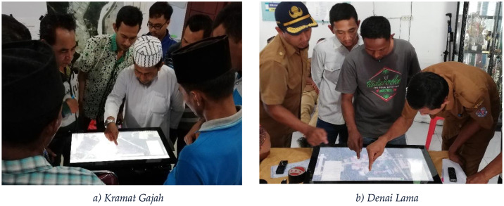
Workshop participants at Kramat Gajah and Denai Lama
Development and results
OGITO’s development was guided by combining Human-Centred Design (HCD) and Agile software development methodologies. This hybrid approach enabled iterative improvements based on real-time feedback and ensured that the tool remained aligned with user needs throughout the process. Six key stages of stakeholder involvement were identified, ranging from understanding the context of use to evaluating the tool in real-world workshops.
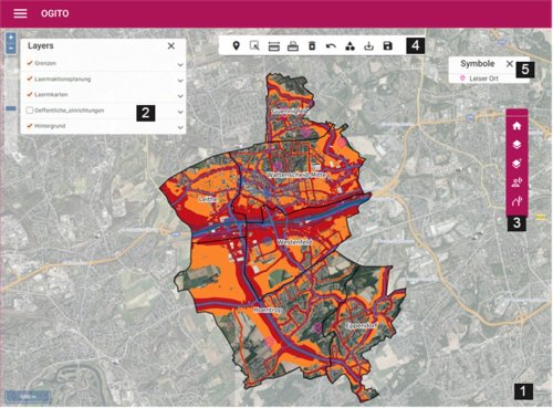
OGITO-noise interface
The results are promising: OGITO not only enhances communication between citizens and planners but also supports more inclusive and data-driven decision-making. Its digital nature allows for future integration with additional datasets, CAD files, and even 3D visualisations, making it a flexible platform for urban planning challenges beyond noise pollution.
At ITC, this project reflects a broader commitment to using geo-information science to address complex societal issues. By combining spatial data, participatory design, and digital innovation, OGITO exemplifies how academic research can lead to practical tools that make cities healthier and more liveable.
Want to learn more about the full research behind OGITO? Read the original article here.
More recent news
 Wed 25 Mar 20264TU.Health Event 2026 sets course for collaborative healthcare innovation
 Tue 17 Mar 2026Rising temperatures can delay the arrival of spring
 Thu 5 Mar 2026Tom Loran says goodbye to ITC
 Thu 19 Feb 2026Project SEEN‑ATLAS Receives European Funding
 Wed 18 Feb 2026Master's in Geo-information Science and Earth Observation recognised as an initial Master's