| Timeline | From March 2016 to 15 March 2019 |
|---|---|
| Theme | Resource security |
| Funded by | FAO |
Achieving food security while using water resources in a sustainable manner will be a major challenge for current and future generations, particularly as we face increased pressures such as economic and demographic growth, and climate change. Agriculture is responsible for 70 percent of all freshwater withdrawals worldwide. That’s why careful monitoring of water productivity in agriculture will allow us to learn how well we are using our water for growing crops and how can we use it better, particularly in water scarce areas.
Improving water productivity often represents the most important avenue for managing water demand in agriculture. Systematic monitoring will help us evaluate water productivity gaps and identify appropriate solutions for closing these gaps.
Water productivity is defined as the quantity or value of output in relation to the quantity of water beneficially consumed to produce this output. Water productivity in agriculture can be expressed as amount of product per unit of water beneficially consumed by the crop.
Project components
- Database (FAO / “FRAME” Consortium, led by eLeaf)
The database is publicly accessible, developed with open access data and open source algorithms. It will provide near real time information covering the period between 2009 and 2019. - Water and land productivity assessment (FAO / UN-IHE)
On the basis of the database, the second component assesses agricultural land and water productivity, inherent productivity gaps, and possibilities to close these gaps. - Water accounting (UN-IHE / FAO)
Through this component, the project assesses, by means of water accounting, the consequences and sustainability of possible increases in water productivity in agriculture. - Capacity development and outreach to farmers (IWMI / UN-IHE / FAO / Network)
This component strengthens capacities of stakeholders at different levels to increase water productivity in a sustainable way, building on collaborations with local partners and research institutions.
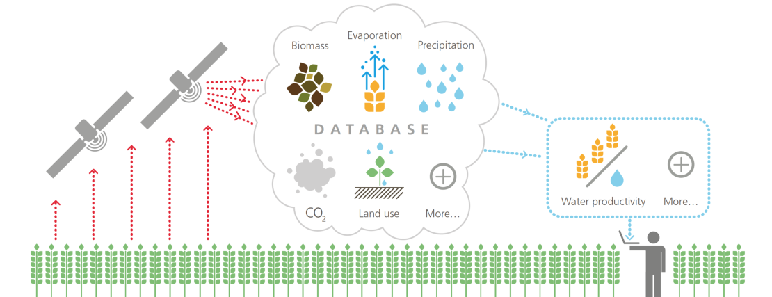
The WaPOR database
WaPOR is the FAO portal to monitor Water Productivity through Open access of Remotely sensed derived data. It monitors and reports on agriculture water productivity over Africa and the Near East and provides open access to the water productivity database and its thousands of underlying map layers. It allows for direct data queries, time series analyses, area statistics and data download of key variables associated to water and land productivity assessments. ITC is involved in FRAME and WaPOR as Database Quality Control and Validation partner.
WAPOR AT A GLANCE
Remote Sensing can help us monitor water productivity in an objective and cost effective way. As of April 2017, the WaPOR platform offers operational and openly accessible data following a technically sound methodology.
Database structure
Available as of April 2017: Level 1 continental (250 m ground resolution); Next releases: Level 2: 18 countries countries and four river basin (100 m), Level 3: 5 pilot areas in Lebanon, Egypt, Ethiopia, Mali (30 m). Seamless monitoring from April 2009 to date, at 10 days or daily (for precipitation and ET0) interval.
Variables: Water productivity, land productivity, actual and reference evapotranspiration, land cover and use, biomass, precipitation, carbon dioxide uptake, yields, harvest index and crop calendar (Level 2 and 3 only).
Key features: Time series and key statistics, open access to data catalogue with more than 6 000 data layers, direct access through APIs.
Contact persons