| Timeline | Started June 2018 |
|---|---|
| Countries | Netherlands |
| Funded by | ESA |
| More info | https://eo4sd-marine.eu |
More than 600 million people live in the Low Elevation Coastal Zone (LECZ): the contiguous area along the coast that is less than 10 m.a.s.l. (Mcgranahan et al., 2007, https://doi.org/10.1177/0956247807076960 ). In this respect, Satellite Earth Observation (EO) technology provides a major benefit to inform and facilitate international development activities in a globally consistent manner. Within EO4SD Marine and Coastal Resources Management project, ITC has created capacity-building training courses and established a satellite-based product of land-based pollution for the Low Elevation Coastal Zone worldwide.
Capacity Building
The capacity building training resources provide detailed information on the state‐of‐the‐art EO data, products and their large‐scale applications to marine and coastal resources.
ITC capacity building training resources developed under the EO4SD marine
The capacity building training resources are offered online as distance education and as face2face training workshops. So far more than 240 individuals have participated in the training sessions offered by ITC under the EO4SD Marine projects.
Land-Based Pollution Service
The rapid urbanisation rate in Low Elevation Coastal Zone leads to massive growth in population and construction, even in restricted areas, increasing the risk of waste contamination of coastal waters.
To address this eminent risk and in response to SDGs 14 and 17, ITC under the EO4SD-Marine has developed a land-based pollution service whereby near-realtime satellite-based maps of suspended and dissolved wastewater are generated for the West African Coast. https://sdg.esa.int/activity/eo4sd-marine-coastal-resources-management-4323
The land-based pollution service provides two types of products targeting the indication of suspended and dissolved waste. They were generated using state of the art ITC model, 2SeaColor ( https://www.utwente.nl/test/itcintra/luigi/water-resources/software-tools-models/), and high-resolution sensor, Sentinel-2 MSI.
The image below shows the suspended waste probability for Accra, Ghana coastal waters on the 22ed of August 2020. At that date, few hotspots of suspended waste probability can be observed at the urban districts.
The land-based pollution products enable options for continuous monitoring in specific coastal areas. Spots that show a high and persistent pollution probability, could be checked by local authorities to identify if there is a source of anthropogenic pollution
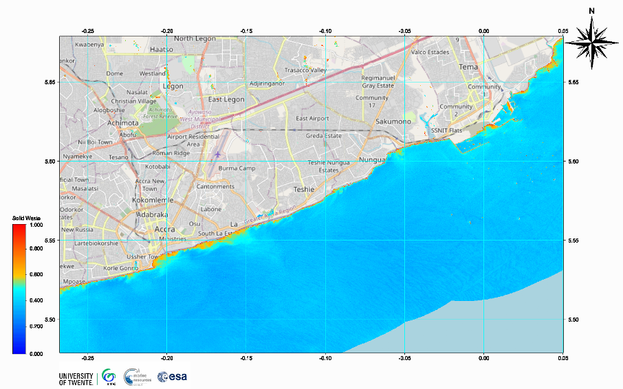
Land based pollution estimated as probability of solid waste at 10 m, resolution, derived from Sentinel-2 MSI image acquired on 22-08-2020 at 10 m resolution
Staff Involved

Contact persons