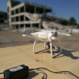
Rescue missions after this week’s devastating earthquakes in Turkey and Syria are well underway. Scientists at the University of Twente have developed various post-disaster solutions to help first responders, but their technology hasn’t made it to practice. ‘We have drones, algorithms and other advanced technology, but our solutions are not used,’ say ITC researchers Norman Kerle and Francesco Nex.
ITC UAV centre | CUTTING-EDGE UAV AND DRONE SOLUTIONS AND EDUCATION
The ITC Faculty at the University of Twente has a long tradition in using UAVs, drones, mapping and photogrammetry. We use drones and unmanned aerial vehicles for geoscience applications, research and capacity-building projects. Over the last decade, ITC has given educational courses on drones and the use of UAVs worldwide.
More recent news
- Mon 10 Feb 2025UAV PHOTOGRAMMETRY CURRENT ONLINE EDUCATIONAL LANDSCAPE
- Mon 9 Sep 2024A Call for UAV Photogrammetry: Applications & Educational Gaps Survey
 Thu 7 Mar 2024Geospatial UAV Centre Webinar series
 Thu 18 Jan 2024Resilience Reflections #22: Sky Guardians
 Thu 7 Dec 2023NeRF and AI for 3D Modeling