Unlock Global Solutions with a Postgraduate Diploma in Geo-information Science & Earth Observation
Designed for young and mid-career professionals, this one-year Postgraduate Diploma programme equips you with the expertise to apply geo-information science and earth observation in your field of interest. You’ll learn to analyse complex problems, apply innovative tools and techniques, and lead multidisciplinary teams in real-world settings.
Based on the First Year of Our Master's Programme
This programme mirrors the structure of the first year of the Master’s in Geo-information Science and Earth Observation, including foundation courses and skill development. In the final quartile, the component Research Skills & Proposal is replaced with a Final Assignment, enabling you to demonstrate what you've learned in a practical context.
Graduates of this diploma receive the same end qualifications as Master's Year One students and can progress into the second year of the Master’s programme.
What You Will Learn
- Gain a critical understanding of spatial tools and technologies
- Explore cutting-edge methods in data acquisition and analysis
- Develop skills for processing, modelling, and visualising spatial data
- Use geo-information to tackle real-world development challenges
- Learn to draft policy recommendations grounded in spatial analysis
Specialisations - Tailor Your Learning Path
Choose from four specialised themes to align your diploma with your career goals:


Learn More & Apply
Read the admission requirements, and start your journey toward becoming a geo-information expert.
Admission requirements
Academic level and background
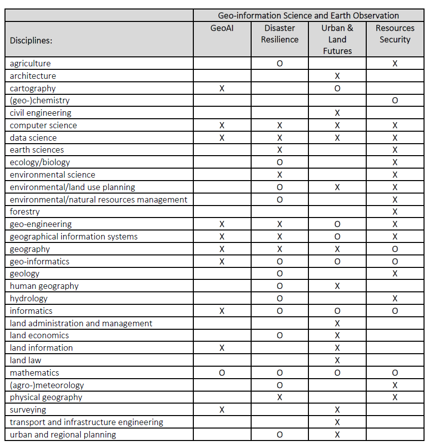
Applicants for the Master’s and Postgraduate diploma in Geo-Information Science and Earth Observation (MSc) should have a Bachelor’s degree or equivalent from a recognised university in a discipline related to the course, preferably combined with working experience in a relevant field.
Overview of eligible undergraduate education disciplines (X), and additional related competences (O) for the Master Geo-information Science and Earth Observation of the Faculty ITC of the University of Twente.
All applications, also those from other backgrounds, will be assessed individually, based on a motivation letter and CV.
The basis requirements per country can be found our website.
The following average scores apply:
- A 3.0 or higher Cumulative Grade Point Average (CGPA) on a 4.0 scale, or
- Upper Second Class standing or higher
NOTE: a Lower Second Class standing may be accepted based on evidence of relevant professional experience and/or other further academic development.
Documentation
The faculty accepts transcripts, degrees, and diplomas in the following languages: Dutch, English, and German. It is at the discretion of the faculty to require additional English translations of all documents in other languages as well.
Language skills
Success in your studies requires a high level of English proficiency. Therefore, prospective students with an international (other than Dutch) degree must meet the English language requirement. As proof that you meet this requirement, you will be asked in the application procedure to upload one of the requested language certificates:
- IELTS (academic) with an overall band score of at least 6.0 (with a minimum sub-score of 6.0 for speaking and writing) and certificates not older than two years.
- TOEFL iBT (internet-based) with an overall score of 80 (with a minimum sub-score of 20 for speaking) and certificates not older than two years. Please note that the University of Twente does not accept the MyBest scores of the TOEFL test.
- Cambridge C1 Advanced Formerly known as; Cambridge English Advanced (CAE), obtained with an A, B or C grade.
- Cambridge C2 Proficiency Formerly known as; Cambridge English Proficiency (CPE) obtained with an A, B or C grade.
Only these internationally recognised test results are accepted. Without a valid certificate, we cannot process your application.
Other requirements
- If you take the test after the application deadline, or you do not have the official English certificate before the application deadline, the University of Twente will not process your application. Therefore, make sure to do the test in advance, as it will take time for you to get the official certificate.
- When applying for a scholarship, the language requirements may be different because scholarship providers may have different requirements.
Exemptions
You are exempted from the English language requirement if you hold:
- a relevant bachelor's degree from an accredited academic institution in the Netherlands
- if you are a national of one of the countries in this list (PDF)
- a three-year bachelor's degree in Australia, Canada (English-speaking part), Ireland, New Zealand, UK or USA. When your awarding institution is in one of these countries, but your teaching institution was not, you are not exempted. The same rule applies to distance (online) education.
Computer skills
You are expected to be familiar with basic computer skills. Basic knowledge of and skills in working with GIS and spatial data is strongly recommended.
Notebook requirements
When you study in an ITC programme, you should have a notebook computer that meets ITC's technical notebook requirements.
If you do not own a notebook that meets the minimum requirements, you could consider buying one through our Notebook Project. The Notebook Project offers discounted notebooks that meet our standards and have the peripherals needed to connect to the ITC networks.
Technical requirements online education and assessment
For online education, we formulated guidelines to guarantee optimal performance. For online oral exams and proctoring during online assessments, the webcam and headset requirements need to be met.
About your diploma
Upon successful completion of this programme you will receive an (Academic Education) Postgraduate Diploma in Geo-information Science and Earth Observation, with the name of the specialisation from the University of Twente.
Along with your Diploma you will receive a Course Record providing all the subjects studied as part of the course. It states: the course code, number, subject, ECTS credits, exam date, location and the mark awarded.