Dr-Ing Roelof Rietbroek has been awarded Vidi funding by the Dutch Research Council for Scientific Research (NWO). Roelof, who is an assistant professor in the Water Resources (WRS) department of the ITC faculty, uses satellite observations to see how atmospheric transport of moisture and river discharge are changing the water cycle and sea level. With this contribution of 800,000 euros, he can develop his own innovative line of research and set up a research group in the coming five years.
Watching the ways of water
Scientists expect an intensification of dry and wet periods resulting from global warming. This is already visible on a global scale, but there are still many questions about how this changing water cycle manifests itself in specific areas.
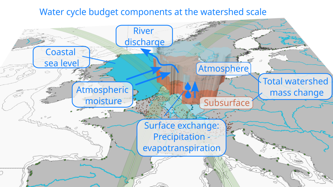
In his research, Roelof Rietbroek and two PhD candidates will use satellite data to map the hydrological regime of river basins in the North Sea region and the Horn of Africa. The aim is to discover to what extent the supply of water vapour via the atmosphere is balanced by the outflow via rivers, and whether this balance is affected by climate change. A second research topic is to look at how this balance plays a part in the variation and change of the sea level, both on a global and regional scale.
CATCHMENT AREAS AS LEAKY BUCKETS
The principle of a river basin can be compared to a leaky bucket. Atmospheric water (vapour) is carried in through the top of the bucket, but at the same time, it leaks back into the ocean through a hole in the bucket. Both a strengthening or weakening of the leak and a different supply of water vapour cause a change in the quantity of water in the bucket. By connecting several buckets (adjacent catchment areas), an interconnected system is created, whose flows will be estimated from satellite data.

For example, the change of water volume in the Rhine catchment is influenced by the balance between water vapour input via the atmosphere and output via rivers. Precipitation, evaporation and transpiration of plants cause an exchange at the interface between land and atmosphere.
WEIGHING AND MEASURING FROM SPACE
The changing water mass in river basins can be measured with the help of the gravity field mission: Gravity Recovery and Climate Experiment (GRACE) and its successor GRACE-Followon, which have been flying in orbit since 2002. The redistribution of water masses creates tiny differences in the observed satellite orbit that are used to 'weigh' the water on the Earth's surface.
The river outflow can be measured with local gauges but also with radar altimetry, a technique that detects reflected radar pulses from the rivers. In the Vidi project, these techniques are combined to obtain a complete picture of the water balance of the river basins.
LIMITS OF THE WATER SUPPLY
The research is not only interesting from a scientific point of view, but is also relevant to water problems in the Netherlands and beyond. Changes in dry and wet periods are forcing the Netherlands, and in particular, Twente, to store the water that precipitates more efficiently in order to bridge drier periods. And also in the Horn of Africa, the current extreme drought is endangering the food security in the region. The research contributes to this discussion by better mapping and understanding the large-scale inflow and discharge of water in the catchment areas.

More recent news
 Tue 3 Feb 2026Natural ice in decline? Bridges may hold the answer
 Wed 21 Jan 2026Climate-resilient cities can start with schoolyards
 Mon 19 Jan 2026Monitoring Infrastructure from Space: From ITC to an International Career
 Fri 12 Dec 2025Retrospective of the UT Climate Event 2025
 Fri 5 Dec 2025Transforming urban policy for a healthier and safer Enschede (and other cities)

