2. Flood hazard analysis using multi-temporal SPOT-XS imagery
In this exercise you will use multi-temporal satellite images to evaluate the flood problem in the confluence area of the Ganges and Jahmuna rivers in Bangladesh, Southwest of the capital of Dhaka. In this area river dynamics are impressive. Rivers change their course for kilometers within years.
You will evaluate the areas covered by water during three periods:
- During the dry season, using a SPOT image from 9-1-1987,
- During a moderately severe flood, using a SPOT image from 7-11-1987,
- During a severe flood, using a SPOT image from 10-10-1988.
Each set of SPOT-XS images consists of three bands; one bands for Red, one for Green and one for Near Infrared. Unfortunately, input map Dry87_1w has a partly black line; this line will be visible throughout the exercise.
Introduction
The SPOT images of the moderately severe flooding period are used to familiarize yourself with the study area and with the contents of the different bands: histograms are made, a color composite is made and pixel info is used to collect some values out of the three bands for different units such as water, vegetation, clouds, shadow and bare soil.
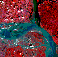
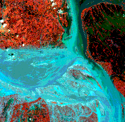
Color composites of the moderate severe flooding period and the severe flooding period.
Band rationing and slicing
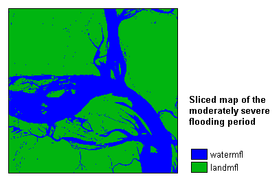
Then, band rationing is applied by using a mapcalc formula: band3 is divided by band1. By inspecting the values in the output map, you have to find the critical value between water and land.
Simply by creating a representation value, the output map of the band rationing may already look classified.
The actual classification is performed using the Slicing operation; the classification is based on the value which distinguishes between water and land as found by yourself.
The procedure is repeated for the bands of the dry period, and for the bands of the severe flooding period.
Combining the sliced maps and quantifying flooded areas
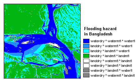
The output maps of the process described above are crossed with each other. The output cross table lists all combinations between land and water in the different periods.
For the output cross map, you will make a representation to color the different units and you will add some annotation.
Finally, with some simple tabcalc formulas in the cross table, the impact areas of flooding are calculated:
- for the moderately severe flooding period (represented as landdry*watermfl*waterfl)
- for the severe flooding period (represented as landdry*landmfl*waterfl).
For more information on this case study, contact:
B.H.P. Maathuis and C.J. van Westen
Department of Earth Systems Analysis,
International Institute for Geo-Information Science and Earth Observation (ITC),
P.O. Box 6, 7500 AA Enschede, The Netherlands.
Tel: +31 53 4 874 391, Fax: +31 53 4 874 336, e-mail: maathuis@itc.nl
Tel: +31 53 4 874 263, Fax: +31 53 4 874 336, e-mail: westen@itc.nl