YOU HAVE A LOT OF FREEDOM TO CUSTOMISE YOUR MASTER’S IN GEO-INFORMATION SCIENCE AND EARTH OBSERVATION.
Within the Master’s in Geo-Information Science and Earth Observation, you build expertise in either general spatial data science or a specific thematic application area, centred around technologies (Geo-AI), the natural environment (Resources Security), or society (Urban Futures and Disaster Resilience). In addition, you can tailor your Master’s to your interests and ambitions by choosing elective courses. The freedom to customise your programme will ensure you become the geo-information specialist you want to be.
Overview of the Master’s
For the Master’s programme you will need to complete a total of 120 credits in 2 years. Each academic year is divided into four quartiles. Within each quartile, all courses run over 10 weeks according to the academic calendar of the University. The start and end dates of all courses in a quartile are therefore the same. Within each week of a quartile, the study load per course can vary. However, the average study load per week is around 42 hours.
Our courses are each 5 EC with a few at 2.5 EC. In brief our Master’s is broken down into 4 parts so that you develop the technical and theoretical giscience skills along with specific skills in an area of interest through the specialisations, while also further developing your professional skills needed in the workplace.
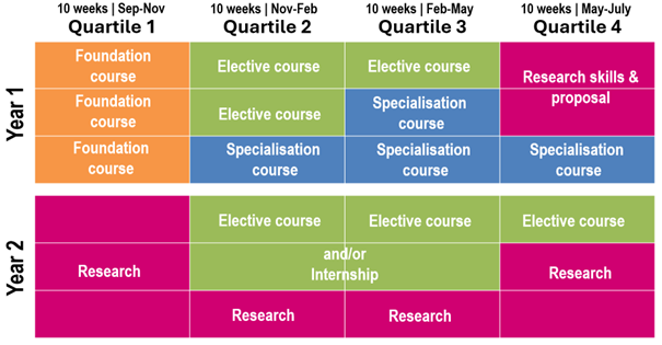
Foundation courses (20EC)
During the foundation courses, you will learn the essential geospatial skills. These are designed to ensure that all participants develop the necessary geospatial skills to be successful for the remainder of the programme. Even if you already have some of these skills, during these courses you will be able to dive deeper and further refine and build on the knowledge you already have. The 15 EC foundation courses in the first year are complemented with 5 EC of professional skills courses, which are taught in the second year.
Strengthen your career prospects with an official QGIS certificate!
 QGIS is the key tool for mastering geospatial concepts through hands-on learning. Successfully completing the foundation courses grants you an official QGIS certificate, a valuable boost to your CV and career in geo-information.
Specialisation courses (20EC)
Specialisation courses (20EC)
We offer five specialisations that are centred around technologies (Geo-AI), the natural environment (Resource Security), and society (Urban and Land Futures and Disaster Resilience).
Electives (35EC)
Electives (35EC)
We offer a range of electives that will enable you to further advance your technical skills, broaden your areas of interest and develop your professional skills. The electives offered each year may change from year to year depending on availability and demand.
Research thesis (45EC)
The research courses (45 EC), include the thesis research project proposal course where you develop a project proposal. During this phase, you will be able to apply what you have learned throughout the programme to a research project of your choice.
Composing and Designing Your Master's
We provide a Master’s where you can choose a pathway suitable for your career goals and background interest, where you will need to select a specialisation.
Specialisation: selecting a specialisation
The master’s Geo-information Science and Earth Observation offers five specialisations. The purpose of these specialisations is to provide students with further depth into an application domain. These are centered around the research strengths and expertise of the Faculty so that you are learning from leaders in the field. These are:
- Disaster Resilience
- GeoAI
- Resources Security
- Urban and Land Futures
- Spatial Data Science
Each specialisation represents the future challenges, technologies, and solutions for the sustainability of our earth’s resources and society. Within each specialisation you are able to further refine your learning pathway.
Research: Selecting a topic for your master's thesis
During the first year, you will meet many ITC faculty and be introduced to the wide-variety and ongoing research and innovations taking place here. We cannot fit everything into our curriculum, but we have integrated different topics into the courses, giving you opportunities to learn more about how geospatial information and technologies are being used as well as providing you with opportunities to start to explore potential research topics that you can develop further as part of your MSc research. For your Master’s thesis, you are free to choose a topic of your choice. You can contribute to an ongoing research project or develop your topic that falls within a research theme at ITC. Together with your supervisors, you develop the focus of the topic of your master's thesis research. To help you choose and be inspired we offer a Thesis Topic Fair where you can learn about different research topics and talk with potential supervisors.
Professional development during your master's
To help you further develop your geospatial competencies we offer a variety of elective courses that will enable you to further advance your technical skills, broaden your areas of interest by gaining additional experience through an internship as well as enhancing your professional skills.
Professional Skills (5EC). We have developed a set of elective courses to help you develop professional skills that are appreciated in the workplace. These courses are essential to let you meet the additional demands of the labour market that go beyond technical skills and domain knowledge. These often called ‘soft skills’ will enhance your chances of securing a job after graduation. We encourage you to take 5 ECs of these courses (2 x 2.5 EC courses).
Internship (15EC). In the second year, you can choose to do an internship where you can apply what you have learned before you graduate, gain additional work experience and explore different industries. You can do an internship at a consulting company, government agency, research institute, or a non-governmental organisation in the Netherlands or anywhere in the world. The choice is yours. To help you choose, we have an internship coordinator who organises Internship Fairs and will help you with setting up an internship.
Career development through International Excursions
As part of the Master’s, you will gain both academic expertise and career skills through career fairs, internships, study trips, and industry engagement.
By interacting with leading research institutes, government agencies, and private companies, students explore career opportunities across the Netherlands, Europe, and beyond. Interactive video conferences with global experts provide additional professional insights.
These experiences help students build valuable connections and prepare for internships, jobs, and long-term careers in geo-information and earth observation.
Discover the exciting internship options at ITC!
Join us on a journey as we follow two Master students, Carolina Pereira Marghidan and John Ifejube, during their internships at the Faculty of Geo-Information Science and Earth Observation (ITC) at the University of Twente. Get ready to witness the impactful work they're doing in their respective placements and gain a glimpse into the future that awaits you as a prospective student.
Find out more
Are you interested in this Master’s and do you want to know more about your study programme and how to compose it? For example, are you curious about the choice of topics or the learning outcomes? You can find out all about it in our Online Study Guide*.
* You are looking at the Study Guide for the current academic year. We always have the desire to strive for improvement. Therefore, the course structure is subject to change.