Earth observation science (EOS) Research
We are living in an era of unprecedented access to geospatial data, driven by rapid advancements in remote sensing technologies. Modern sensors—on platforms ranging from satellites and aircraft to drones—are capturing data in ever-increasing volumes, with higher spatial, spectral, and temporal resolutions. These technological developments enable the detailed observation of Earth’s surface, allowing us to monitor and analyze natural and urban environments at both local and global scales.
At the Earth Observation Science (EOS) department, our research is motivated by the urgent societal and environmental challenges facing our planet. We work in interdisciplinary teams to develop innovative geospatial applications that support sustainable development, environmental monitoring, and disaster resilience. Our work is closely aligned with the United Nations Sustainable Development Goals (SDGs).
EOS researchers develop and apply advanced machine learning and Geospatial Artificial Intelligence (GeoAI) techniques to monitor urbanization, agricultural landscapes, forests, and cryospheric regions. Key research areas include (but are not limited to):
- Design of techniques for Earth observation data acquisition, fusion and analysis
- Develop techniques for image and point cloud data processing and analysis
- Mapping and monitoring agricultural areas and smallholder farms through boundary delineation, crop type classification, and crop nutrient estimation.
- Identifying and characterizing deprived urban areas (e.g., informal settlements), supporting progress tracking of SDG Indicator 11.1.1.
- Developing real-time UAV-based analysis tools for disaster response and precision agriculture.
- Applying Interferometric Synthetic Aperture Radar (InSAR) techniques to monitor ground deformation and assess the stability of slopes, coastlines, and critical infrastructure.
- Mapping and monitoring forests and land resources, including deforestation, selective logging, land degradation, and evaluating the effectiveness of ecosystem restoration measures.
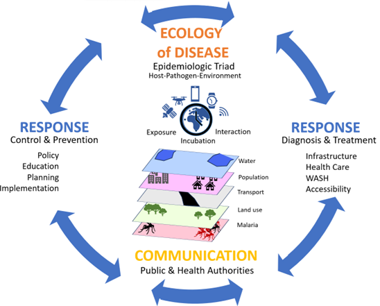
- Applying geospatial technologies and GIScience in GeoHealth to visualize where and when diseases occur in space and time—providing context, identifying affected populations, understanding underlying causes, and supporting targeted interventions.
To transform raw data into actionable information, EOS focuses on Earth observation data acquisition, fusion, and analysis. We develop cutting-edge GeoAI methodologies for integrating and interpreting multi-source remote sensing data—supporting timely, accurate, and scalable solutions for decision-makers and stakeholders worldwide. We subdivide our research into a more technology and algorithm-oriented domain (Earth Observation Data Acquisition, Fusion and Analysis) and a special application domain (Geohealth) in which the value of Earth Observation data receives increasing attention.


EOS Detailed information
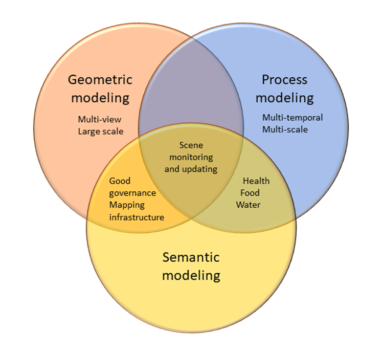
SEMANTIC MODELLING
Semantic modelling aims to extract meaningful, reliable information from sensor data to support decision-making in public and private domains. Humans interpret geospatial data by recognizing object type and characteristics such as size, shape, and colour, as well as spatial relationships, temporal patterns, and imaging effects. Translating this capability into automated systems requires advanced machine learning techniques. While supervised classification algorithms can learn class-specific features from training data, these alone are insufficient for tasks involving 3D geometry (e.g. point clouds) or temporal and spatial dynamics, such as super-resolution mapping or class transitions over time. Addressing these complexities requires the integration of spatial statistical methods and quality-aware modelling strategies.
Research objectives:
- Develop machine learning methods for Earth observation image analysis and data fusion.
- Design machine learning algorithms and deep learning architectures for semantic segmentation, object detection, and vectorised object delineation, making optimal use of available sensor and geospatial data sets.
- Develop machine learning methods for semantic segmentation, object detection, and tracking to run on edge devices in real-time.
GEOMETRIC MODELLING
Traditionally, large-scale geo-information focused on 2D spatial data with terrain heights represented separately through raster grids or Triangulated Irregular Networks (TINs). In recent years one observes a growing use of 3D geo-information in applications like urban planning, virtual tourism, and management of road and railroad infrastructure. Standard aerial photographs and land surveying are no longer the exclusive data sources for the extraction of geo-information. They have been complemented by data acquired by airborne oblique cameras, mobile and terrestrial laser scanners, and video and consumer cameras used from the ground or in low flying UAVs as well as field observation data. In this way, very high-resolution data are obtained that provide new opportunities for automation of geo-information extraction. In the coming years, the plans are to widen the focus to the modelling of objects in urban environments and road and railroad infrastructure. We also plan to make increasing use of data acquired by low-cost sensors. Geostatistical upscaling and downscaling methods are increasingly being used to synchronize data at a common platform. Issues of positional accuracy are still being extensively researched.
Research objectives/questions
- Development of methods for registration of point clouds and images;
- Development of methods to generate 3D reconstructions in real-time from mobile sensors and on edge devices.
- Development of AI-based methods to produce point clouds and 3D models from different inputs.
- Development of methods to fully capture objects in terms of a dense point cloud by either range or optical cameras;
- Incorporate generic knowledge on building shapes and integrating features extracted from point clouds and images;
- Explore the potential of oblique images and (multi-temporal) point clouds for change detection and change classification;
- Generalise procedures for roof shape recognition to identify the most common objects in road corridors;
- Develop, improve and fine-tune methods for up- and downscaling.
PROCESS MODELLING
Processes modelling concern the development of models for spatial phenomena in time, such as biophysical and socio-ecnomic variables, flooding events, deforestation and the spread of diseases. Such spatio-temporal processes have a specific period of interest, for example in the time of rapid spreading, when a close monitoring by integrating remote sensing images, models and field data is important. The scale of change is critical, and observation technology should be tuned to it. We may expect a further increase in the specific spatial resolutions, the frequency of observations and the spectral resolution of optical sensors. The role of radar has been explored in InSAR and related studies, whereas lidar has been partly addressed for monitoring purposes. It is often a critical question how to include the determining information to improve the descriptive model.
Research objectives/questions
The research questions related to processes focus on the following:
- Identify appropriate solutions in space, frequencies in time, and spectral ranges for optimal process modelling.
- Design sensor systems that are optimal for monitoring spatio-temporal processes;
- Collect and interpret reliable information from multi-temporal remote sensing data.
- Design models that accurately capture the evolution of spatial processes over time.
- Integrate machine learning-based approaches with physical models to estimate biophysical variables.
- Quantify geo-statistical relationships in process dynamics.
- Assess and model uncertainties in both statistical and machine learning frameworks.
Research Group Leaders


Research group
The research group carrying out the projects in this research theme include staff members of ITC and graduate students, some of whom carry out their research in sandwich constructions with partner universities or research organizations.


