Owing to increased vulnerability and climatic extremes, we face the rapidly growing impact of disasters worldwide. There is an urgent need to incorporate the concepts of disaster risk management into planning, sustainable development and environmental impact assessment. Disaster risk management requires the assessment of risk, which is a multidisciplinary endeavour.
The course explains how to conduct a risk assessment using spatial information on hazards, elements at risk and vulnerability with the aid of GIS and remote sensing, and how this information can be used in risk management, focusing on urban areas.
For whom is the course relevant?
This course is designed for all those who have to carry out risk assessment and require knowledge and skills in using a GIS to handle the necessary the procedures, such as professionals working in governmental and non-governmental organizations, planners, engineers, architects, geographers, environmental specialists and university teachers. Some basic background in GIS is desirable, although not strictly necessary as the course follows a step-by-step approach that enables participants to rapidly acquire the basic skills in handling GIS software.
What will be achieved?
The course will guide participants through the entire process of risk assessment on the basis of a case study of a city exposed to multiple hazards. At the end of this course, you will be able to:
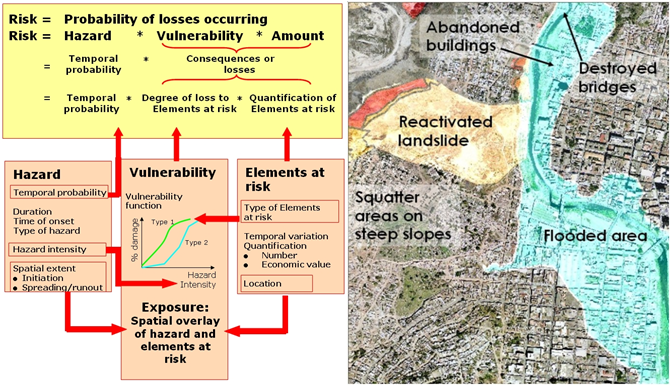
- understand the concepts of hazard assessment, elements-at-risk mapping, vulnerability assessment and risk assessment
- formulate the spatial data requirements for hazard- and risk assessment & practice with various exercises in remote sensing and GIS
- use GIS to generate an elements-at-risk database
- apply various methods for vulnerability assessment
- generate risk maps using qualitative and quantitative methods
- understand how risk assessment is used in risk reduction and disaster preparedness.
What is the course content?
The course is composed of a number of sessions. There are two main study materials 1: the digital Guidebook and 2. the digital Exercise book. Each guide book session is complemented with additional links, tasks and additional online tutorials. Each session also has exercises and assignments in the “Exercise book”. The course is based on a study load of one module of three weeks (5 EC), which is offered in online form over a period of six weeks. All material is presented in our digital learning environment Canvas. Below is a summary of the sessions and detailed content.
Session | Theory | Exercise |
|---|---|---|
00: Getting started | Set up a Canvas account; install ILWIS software; get to know the tutors and fellow students | |
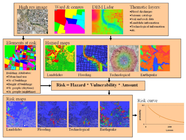
01: Introduction to risk assessment | Introduction to disaster risk management and risk assessment | Generation of a hazard profile using disaster databases; introduction to ILWIS and the RiskCity dataset; learn the various hazard problems by evaluating high-resolution images |
02: Obtaining spatial data for risk assessment | Presentation of data requirements for the various types of hazards; sources of spatial data | Defining spatial data requirements for risk assessment; internet search for information on risk assessment; acquiring free and low-cost data; generating 3D image data using Google Earth; stereo image interpretation |
03: Hazard Assessment | Hazard types; main concepts of hazard assessment; frequency-magnitude relationships | Frequency assessment; selection of hazard assessment examples for: flooding, landslides, earthquakes, coastal, volcanic, and technological hazards; besides GIS exercises also some remote sensing applications and tutorials using Sentinel1 data. |
04: Elements-at-risk assessment | Types of elements at risk; classification of buildings, infrastructure, lifelines, critical facilities; population information; collection of elements-at-risk information | Generating an elements-at-risk database from scratch; generating an elements-at-risk database using available data (building footprint map, census data and LiDAR) |
05: Vulnerability assessment | Types of vulnerability; social vulnerability; physical vulnerability; methods of vulnerability assessment; participatory GIS; spatial multi criteria evaluation | Defining vulnerability curves; spatial multicriteria evaluation for vulnerability assessment |
06: Risk assessment | Loss estimation models; HAZUS; qualitative risk assessment; QRA; basics of flood risk, seismic risk, landslide and technological risk assessment | Creating risk curves; selection of risk assessment method: flooding, earthquakes, landslides, technological hazards. |
07: Risk management | Risk evaluation; risk governance; risk communication; cost-benefit analysis; using risk information for emergency planning; spatial planning, and environmental impact assessment | Multi-hazard risk assessment for buildings; assessing economic losses; cost-benefit analysis |
08: Final project and examination | Discussion: Final project: Examination: |
Why choose this course?
The course has been designed over a long period of time and has been tested many times in different countries. It is based on a coursebook with assignments and an exercise book with GIS exercises. Active interaction with lecturers and fellow students takes place via the internet. The general approach of the course is task-based learning that blends theory and practice. The study load is 20 to 24 hours per week.
Note: In the Guide book and Canvas (our digital learning environment) many additional tasks and study materials are offered (background reading). It is your choice to select what is interesting to you. It is impossible to do all! Be selective!!
Essential course parts: the GIS exercises, the final project and the exam.
About your diploma
Upon successful completion of this course you will receive a Certificate which will include the name of the course.
Along with your Certificate you will receive a Course Record providing all the subjects studied as part of the course. It states: the course code, subject, ECTS credits, exam date, location and the mark awarded.
If you decide to follow a full Postgraduate or Master's course at ITC, and after approval of the Examination Board, you will be exempted from the course(s) you followed successfully as an online course.
Admission requirements
Academic level and background
Applicants for an online course should have a Bachelor degree or equivalent from a recognised university in a discipline related to the course, preferably combined with working experience in a relevant field.
Documentation
The faculty accepts transcripts, degrees and diplomas in the following languages: Dutch, English, and German. It is at the discretion of the faculty to require additional English translations of all documents in other languages as well.
Language skills
Success in your studies requires a high level of English proficiency. Therefore, prospective students with an international (other than Dutch) degree must meet the English language requirement. As proof that you meet this requirement, you will be asked in the application procedure to upload one of the requested language certificates:
- IELTS (academic) with an overall band score of at least 6.0 (with a minimum sub-score of 6.0 for speaking and writing) and certificates not older than two years.
- TOEFL iBT (internet-based) with an overall score of 80 (with a minimum sub-score of 20 for speaking) and certificates not older than two years. Please note that the University of Twente does not accept the MyBest scores of the TOEFL test.
- Cambridge C1 Advanced Formerly known as; Cambridge English Advanced (CAE), obtained with an A, B or C grade.
- Cambridge C2 Proficiency Formerly known as; Cambridge English Proficiency (CPE) obtained with an A, B or C grade.
Only these internationally recognised test results are accepted. Without a valid certificate, we cannot process your application.
Other requirements
- Ensure you have obtained a valid English test result before the application deadline. If your application is accompanied by a language test score report with a test date after our application deadline, we will not process it. Therefore, make sure to do the test in advance, as it will take time for you to get the official certificate.
- When applying for a scholarship, the language requirements may be different because scholarship providers may have different requirements.
Exemptions
You are exempted from the English language requirement if you hold:
- a relevant bachelor's degree from an accredited academic institution in the Netherlands
- if you are a national of one of the countries in this list (PDF)
- a three-year bachelor's degree in Australia, Canada (English-speaking part), Ireland, New Zealand, UK or USA. When your awarding institution is in one of these countries, but your teaching institution was not, you are not exempted. The same rule applies to distance (online) education.
Computer skills
To follow online education you must have basic computer experience, regular access to internet, and e-mail. For some courses, additional computer skills are required (see description of specific course).
Technical requirements online education and assessment
For online education, we formulated guidelines to guarantee optimal performance. For online oral exams and proctoring during online assessments, the webcam and headset requirements need to be met.
GIS and remote sensing
Most online courses, except for the introductory course, require knowledge of, and skills in, working with GIS and/or digital image processing of remotely sensed data.
Candidates are asked to provide proof of identity during the registration process.
Hardware and software requirements
Since the computer is used for both practical exercises and communication via the internet you are expected to have a computer capable of running ILWIS (standard PC or laptop is OK) and an internet connection. The course is made for the Open Source GIS software ILWIS (Integrated Land and Water Information Systems. We will use email and skype for individual communication and a discussion board in Canvas for group communication. There is also a Chat function in Canvas.
Besides ILWIS there are some exercises and tutorials with Sentinel 1C data using SNAP.
All course material can be downloaded from Canvas, our educational system. Besides ILWIS you will work with MS Excel and Word.
The study load is at least 20-24 hours per week. You have to make choices in tasks and offered links and background study materials in order not to make too many study hours. Try to construct your own simple anaglyph glasses for stereo viewing in one of the exercises.
What more there is to know?
This online course is based on a module of one of ITC's degree courses. Successful completion will lead to exemption for that course in the degree course.
The course is developed by a group of people. Coordination is by: