| Student: | J. Pratomo MSc |
|---|
Background
Slum reduction and improvement are on the global agenda in the recent decade. Nonetheless, the enormous growth of cities, particularly in the global south, combined with the lack of the capacity of local authorities to provide adequate housing, has resulted in the rapid growth of urban slums [1,2]. Although the global number of urban slum dwellers between 2000 and 2014 has decreased from 39 per cent to 30 per cent, respectively, the absolute number remains growing [3]. Within the Sustainable Development Goals (SDGs) the vision towards slum reduction is stated as part of indicator 11.1, which is to attain universal access to adequate, safe and affordable housing by 2030 [4].
To achieve the SDG indicator 11.1, updated and reliable data on slums is critical to implement and evaluate the effectiveness of slum improvement programs. However, two crucial knowledge gaps have prevented the efforts of monitoring the SDG target. First, the data unavailability, not allowing to differentiate the diversity of urban areas, and second, siloed approaches in mapping the deprived areas [5]. Furthermore, current approaches such as survey-based methods (i.e., census data), have failed to grasp the dynamics of slums due to their long temporal gap and the degree of aggregation [6], which makes the information collected obsolete by when it is used [7].
The increasing availability of (very)-high-resolution multi-temporal remote sensing (RS) imagery can be used to capture the spatial information in almost real-time and with frequent time intervals [7], allowing to monitor urban dynamics. Previous studies discussed the utilisation of multi-temporal RS imagery with regards to evaluating or monitoring policy and programs, e.g., for forestry management [8], land use management [9] and crop management [10]. However, slums and non-slums often share a similar material composition that leads to a similar reflectance [11]. Therefore, it is crucial to not only perform pixel-based classification based on spectral values [12] but add additional image features (i.e., shape, texture, density, tenure status) to reduce misclassification [11].
Among various approaches in the RS domain, Object-based Image Analysis (OBIA) has the potential to extract slum areas by combining spectral as well as contextual information [13]. The more conventional methods in analysing slums using OBIA is based on the development of a ruleset (e.g., [7,11,14]). In ruleset based OBIA, the approach is to transform slums characteristics selected by domain expert into a parameter that can be known by the computer. The Generic Slum Ontology (GSO) [14] developed to assist the slum detection within OBIA by providing a generic concept of slums [14] using morphological indicators in three spatial levels (i.e., environs, settlement and object) [11].
Since the GSO was developed as a generic concept of slums [15], the GSO needs to be adapted to each local context by incorporating the local knowledge [6] since slums characteristics may differ across different places [16] as well as their developmental stages [17].
Despite the necessity of adaptations as mentioned above, the needs of policymakers regarding slum information persist. They require a fast and reliable source of slum information to support planning and decision making. Also, they need a robust approach that can be implemented in a different place and scale (e.g., district, city, national level). The ability of a ruleset to map slums and to produce comparable outputs across different spatiotemporal conditions can be called transferability [11]. Thus, promoting the transparency of the adaptations for transferability is crucial to ensure the objectivity of the ruleset [18].
The more recent approach in detecting slum settlement is to utilise machine-learning algorithms (e.g., [19,20]), which have been combined with OBIA (e.g., [21]). The usage of the machine-learning algorithms allows tackling several shortcomings of the rule-based OBIA, particularly the needs of adaptations of the ruleset when it is applied in different conditions (e.g., locations and time).
Research Problems
Previous studies have discussed the concept and measurement of transferability within OBIA-based slum detection approaches, for instance, by focusing on the comparability of the results [11,22], or the degree of adaptation [7,23], or by utilising the accuracy as a benchmark [24]. However, measuring the transferability only by accuracy indicators has some shortcomings [24], due to the three sources of uncertainties in the OBIA-based slum detections:
1. Uncertainties in the concept of slums
Although slums can be often recognised as homogeneous zones that share specific spatial characteristics, they can show different appearances and definitions depending on the local context [25]. Thus, the main questions when determining the location and extent of slums is whether slums exist and if they exist, how their extent can be determined. Such uncertainties were referred to as existential and extensional uncertainty [26]. Regarding existential uncertainty, the different experience and the way to conceptualise slums (i.e., indicators used) may lead to different perceptions of whether slums exist. Meanwhile, regarding extensional uncertainty, manual image interpretation is commonly used as reference data in OBIA [27], often producing ambiguous results as interpreters may differ in the level of detail when delineating objects [25,28,29].
2. Uncertainties in the Acquisition of Imagery
The occurrence of uncertainties in producing geographic data is inevitable [30], and the level of uncertainties will propagate through the whole process chain [31]. In a previous study [32], the usage of multi-temporal imagery has resulted in a false-positive result due to the changes in viewing angles among two different acquisition period of Pleiades 2 imagery.
3. Uncertainties in OBIA
In OBIA, the effort to relate geographic features and image object depends on two steps, namely segmentation and classifications [33]. Segmentation is aimed to segment an image to homogenous units that allow producing meaningful image objects, according to the homogeneity or heterogeneity of spectral or shape criteria [34]. Nonetheless, most of the initial image objects do not qualify as a significant object, i.e., over or under segmented [35]. Thus, over segmented objects require a merge process into larger objects, and under segmented objects require a further segmentation into smaller objects.
In our previous research [24,32], we have demonstrated the impact of uncertainty on the spatial and temporal replicability of OBIA-based slum detection methods. In Figure 1, we summarise the gap between the needs and expectations of the policymakers and the uncertainties related to OBIA-based slum detection.
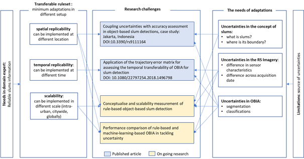
Figure 1 Research Gap
To fill the gap of our research, we will focus on conceptualising and measuring the scalability of rule-based OBIA in the different place and scale (e.g., district, city, national level). Also, we will focus on exploring the performance of machine-learning-based OBIA in detecting slum as compared to the ruleset-based OBIA, considering the uncertainties mentioned above.
Research Objective
The objective of our research is to understand how uncertainties affect the transferability for implementing OBIA-based slum detection.
We divide the objective of our research into the following sub-objectives:
1. To analyse the impact of uncertainties in measuring the accuracy of OBIA-based slum detection in the context of assessing transferability.
Paper published: Jati Pratomo; Monika Kuffer; Javier Martinez; Divyani Kohli Coupling Uncertainties with Accuracy Assessment in Object-Based Slum Detections, Case Study: Jakarta, Indonesia. Remote Sensing 2017, 9, 1164, doi:10.3390/rs9111164.
Object-Based Image Analysis (OBIA) has been successfully used to map slums. In general, the occurrence of uncertainties in producing geographic data is inevitable. However, most studies concentrated solely on assessing classification accuracy and neglecting the inherent uncertainties. Our research analyses the impact of uncertainties in measuring the accuracy of OBIA-based slum detection. We selected Jakarta as our case study area because of a national policy of slum eradication, which is causing rapid changes in slum areas. Our research comprises of four parts: slum conceptualisation, ruleset development, implementation, and accuracy and uncertainty measurements. Existential and extensional uncertainty arise when producing reference data. By comparing the manual delineations of slums from local experts with OBIA slum classification may results in four combinations: True Positive, False Positive, True Negative and False Negative. However, the higher the True Positive (which lead to a better accuracy), the lower the certainty of the results, which demonstrates the impact of extensional uncertainties. Our study also demonstrates the role of non-observable indicators (i.e., land tenure), to assist slum detection, particularly in areas where uncertainties exist. In conclusion, uncertainties are increasing when aiming to achieve a higher classification accuracy by matching manual delineation and OBIA classification.
2. To analyse the challenges in measuring transferability of multi-temporal OBIA-based slum detections.
Paper published: Pratomo, J.; Kuffer, M.; Kohli, D.; Martinez, J. Application of the trajectory error matrix for assessing the temporal transferability of OBIA for slum detection. European Journal of Remote Sensing 2018, 51, 838–849, doi:10.1080/22797254.2018.1496798.
High temporal and spatial-resolution imageries are a valuable data source for slum monitoring. However, the transferability of OBIA methods across space and time remains problematic, due to the complexity of the term "slum". Hence, transparency is essential when analysing the transferability of OBIA methods for slum mapping. Our research developed a framework for measuring the temporal transferability of OBIA methods employing the trajectory error matrix (TEM). We found relatively low trajectory accuracies indicating low temporal transferability of OBIA methods for slum monitoring using point-based assessment methods. However, the analysis of change needs to be combined with an analysis of the certainty of this change. It is done by considering the context of the change to deal with common problems such as variations of the viewing angles and uncertainties in producing reference data on slums.
3. To conceptualise and measure the scalability of rule-based OBIA for slum detections
Planned Paper: Assessing the Scalability of Local Ruleset of Object-based Slum Detection into Citywide Applications in Jakarta: Opportunity and Challenges
The existence of various public facilities and high economic opportunities has attracted an increasing number of people to live in Jakarta. However, due to the low capacities of the local government to cope with the high rate of urbanisation, e.g. providing public housing, many low-income people are living in sub-standard housing areas. At the national level, the government has set the 100-0-100 target (100% access to clean water, 0% slums, 100% access to sanitation) and invested up to 9.5 billion USD from 2014 to 2019 [36]. However, to monitor the achievement of this specific target, also related to the SDG indicator 11.1.1, is not straightforward due to several factors. First, different indicators are used to identify and measure slums; the national and provincial government use 7 and 11 indicators, respectively, and these also differ in the formulation. Second, the existence of urban village (kampungs) has blurred the conceptual boundary between slum and non-slum areas in Jakarta due to similarities in their morphological characteristics, such as overcrowdedness (i.e., high built-up and population density) and its irregular morphological features [24]. Third, different units of measurement are employed. For example, the national government tends to use settlement level characterisation based on similarities of morphological characteristics.
Meanwhile, the Government of Jakarta uses neighbourhoods as a unit, called RW Kumuh (Slum Neighbourhood), and they have surveyed this unit since 1997 almost every three years [37]. However, from the perception of the users (i.e., government employees), the usage of RW Kumuh data is not practical for them, because it cannot illustrate the actual extents of the slums (Figure 2). There is thus a need for the development of a methodology that can deal with the different ways of measuring at different scales. Here, a possible solution would be the use of RS based slum detections using OBIA.
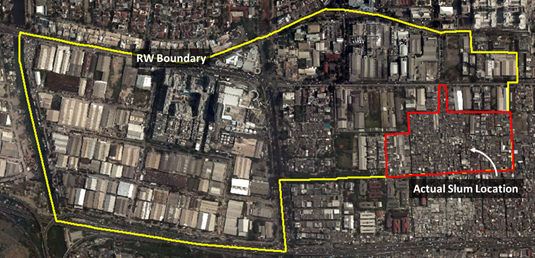
Figure 2 Situations in RW7, Penjaringan Sub-district, Jakarta. The yellow line indicates the boundary of the RW, where the red line indicates the actual slum locations. This neighbourhood is predominately by the warehouse area and the existence of a small slum pocket.
To assist the slum detection through OBIA, researchers developed a generic concept of slums through the generic slum ontology (GSO) [15]. However, the GSO needs to be adapted to each local context by incorporating the local knowledge [6] since slums characteristics may differ across different places [16] and the developmental stages of slums [17]. Albeit, how different spatial characteristics across slums within the city may require adaptations of a ruleset (required for object-based image classification), remains unanswered. Thus, the main question is to understand how a robust ruleset can be implemented at a citywide level, in terms of the degree of adaptations needed to result in comparable accuracy result. Hence, in our research, we will focus on the scalability aspect of the ruleset.
It is essential to understand how the local experts perceive the slums and to understand to what extent the perception of slums varies in different locations in Jakarta. We will employ several steps in our research, as follow:
1. First, we will start by developing a reference dataset and conceptualise slum characteristics from the local experts' perceptions. For this, we will be asking experts from various backgrounds to indicate where the slum areas are located. The expert will draw the boundary of the slums from VHR imagery and will be asked to indicate the characteristics that they used when determining the boundary of slums (e.g., irregularity, associations with the river, building density). In the interviews, we will also be asking the preference of the local experts regarding the level of detail of the data (e.g., building, neighbourhoods, district, city) that are useful for them.
2. Second, we will incorporate these characteristics of slums that were mentioned by the local experts in developing the local ruleset.
3. Third, we will test the scalability of the ruleset into the various setup:
a. We test the ruleset for different areas, which are having the same degree of agreement of the slum boundaries (delineated by experts).
b. We test the ruleset across the different areas with different degrees of agreement of the slum boundary (delineated by experts).
c. We test the ruleset in a different scale (e.g., from sub-district – district – city part – entire city).
4. Fourth, we compare the scalability of the ruleset across different setup (as mentioned in the third step) by using the reference data generated from the first step.
5. Fifth, we will discuss the impact of uncertainty towards the scalability aspect in the setup mentioned above. We then reflect how the uncertainty aspect of slum detection impacted the decision-making process from various levels of policymakers.
Within our first and second research paper, we implemented our ruleset in one slum pocket within the city. Meanwhile, our third paper will contribute to assessing the scalability aspect in a larger and more diverse area. Also, it is also expected that our research will give a better understanding regarding the usefulness of OBIA based slum detection in answering the different needs of information across different level of policymakers.
4. To compare the performance of rule-based and machine-learning-based OBIA to tackling uncertainty in slum detections.
Planned Paper: Comparing the Performance of Rule-based and Machine-Learning Based OBIA in Tackling the Intra-urban Variations of Slums
Rule-based OBIA for slum detection has the advantage in linking the domain expert knowledge of slums with object detection through the ruleset. However, since the ruleset is made upon a set of thresholds that are used to distinguish slum and non-slums, it is often only applicable in a specific area. Thus, adaptations of rulesets are necessary for producing a comparable result in a different part of the city. Variations of slum characteristics can be found not only between cities but also within the city. In Jakarta, we may find different characteristics of slums, for instance, slums in the riverbank, slums along the coastline, slums in the CBD.
In the case of Jakarta, the boundaries of slums are often vague, mainly due to the existence of the urban village (kampung). Our previous research [24] indicates that the morphological similarities of slum and non-slums in kampungs have resulted in a different agreement of slum boundaries, which resulted in an ambiguous reference data.
Machine-learning based OBIA allows reducing human interventions in developing the ruleset. However, in order to develop a good classifier, it requires accurate training data. Therefore, our research will explore the impact of uncertainty in reference data affecting the accuracy of ML-based OBIA. We also will examine whether ML-based OBIA can overcome the limitations of rule-based OBIA, i.e., by solving the needs of adaptations.
We will employ several steps in our research, as follow:
1. We will use the insights from the first paper and the result of the third paper as an input for the fourth paper, particularly the insights on and the reference data based on the local expert delineations of slums.
2. We implement the different types of slums, i.e., delineated slum areas that have different degrees of the agreement, as training sets for ML-Based OBIA and examine the impact on results, e.g., via measured accuracies.
3. Finally, we will discuss whether ML-based OBIA can overcome the limitations of Rule-based OBIA in slum detection, with regards to the various type of uncertainties that exist.
1. Centre on Housing Rights and Evictions Women, Slums and Urbanization: Examining the Causes and Consequences; Park, R., Ed.; COHRE Secretariat: Geneva, 2008; ISBN 978-92-95004-42-9.
2. Ooi, G.L.; Phua, K.H. Urbanization and slum formation. Journal of Urban Health 2007, 84, 27–34, doi:10.1007/s11524-007-9167-5.
3. UN-Habitat Urbanization and development: emerging futures; World cities report; UN-Habitat: Nairobi, Kenya, 2016; ISBN 978-92-1-133395-4.
4. Open Working Group SDG Sustainable Development Goals Open Working Group proposal for Sustainable Development Goals; United Nations, 2014;
5. Kuffer, M.; Thomson, D.R.; Boo, G.; Mahabir, R.; Grippa, T.; Vanhuysse, S.; Engstrom, R.; Ndugwa, R.; Makau, J.; Darin, E.; et al. The Role of Earth Observation in an Integrated Deprived Area Mapping “System” for Low-to-Middle Income Countries. Remote Sensing 2020, 12, 982, doi:10.3390/rs12060982.
6. Kohli, D.; Sliuzas, R.; Kerle, N.; Stein, A. An ontology of slums for image-based classification. Computers, Environment and Urban Systems 2012, 36, 154–163, doi:10.1016/j.compenvurbsys.2011.11.001.
7. Hofmann, P.; Strobl, J.; Blaschke, T.; Kux, H. Detecting informal settlements from Quickbird data in Rio de Janeiro using an object based approach. In Object-Based Image Analysis; Springer, 2008; pp. 531–553 ISBN 3-540-77057-7.
8. Islam, K.N.; Rahman, M.M.; Jashimuddin, M.; Hossain, M.M.; Islam, K.; Faroque, M.A. Analyzing multi-temporal satellite imagery and stakeholders’ perceptions to have an insight into how forest co-management is changing the protected area landscapes in Bangladesh. Forest Policy and Economics 2019, 101, 70–80, doi:10.1016/j.forpol.2019.01.011.
9. Simmons, B.A.; Law, E.A.; Marcos-Martinez, R.; Bryan, B.A.; McAlpine, C.; Wilson, K.A. Spatial and temporal patterns of land clearing during policy change. Land Use Policy 2018, 75, 399–410, doi:10.1016/j.landusepol.2018.03.049.
10. Yang, L.; Wang, L.; Huang, J.; Mansaray, L.R.; Mijiti, R. Monitoring policy-driven crop area adjustments in northeast China using Landsat-8 imagery. International Journal of Applied Earth Observation and Geoinformation 2019, 82, 101892, doi:10.1016/j.jag.2019.06.002.
11. Kohli, D.; Warwadekar, P.; Kerle, N.; Sliuzas, R.; Stein, A. Transferability of object-oriented image analysis methods for slum identification. Remote Sensing 2013, 5, 4209–4228, doi:10.3390/rs5094209.
12. Jain, S. Use of IKONOS satellite data to identify informal settlements in Dehradun, India. International Journal of Remote Sensing 2007, 28, 3227–3233, doi:10.1080/01431160600705122.
13. Ebert, A.; Kerle, N.; Stein, A. Urban social vulnerability assessment with physical proxies and spatial metrics derived from air- and spaceborne imagery and GIS data. Natural Hazards 2009, 48, 275–294, doi:10.1007/s11069-008-9264-0.
14. Hofmann, P. Defining Robustness Measures for OBIA Framework. In Global Urban Monitoring and Assessment through Earth Observation; Weng, Q., Ed.; CRC Press, Taylor & Francis, 2014; pp. 303–324.
15. Mathenge, C.W. Application of Object Oriented Image Analysis in Slum Identification and Mapping-The Case of Kisumu, Kenya. Master Thesis, University of Twente, 2011.
16. Pratomo, J. Transferability of The Generic and Local Ontology of Slum in Multi-temporal Imagery, Case Study: Jakarta. PhD Thesis, University of Twente, 2016.
17. Kohli, D.; Kerle, N.; Sliuzas, R. Local ontologies for object-based slum identification and classification. In Proceedings of the Proceedings of the 4th GEOBIA; Rio de Janeiro, 2012; p. 201.
18. Anders, N.S.; Seijmonsbergen, A.C.; Bouten, W. Rule Set Transferability for Object-Based Feature Extraction: An Example for Cirque Mapping. Photogrammetric Engineering & Remote Sensing 2015, 81, 507–514, doi:10.14358/PERS.81.6.507.
19. Leonita, G.; Kuffer, M.; Sliuzas, R.; Persello, C. Machine Learning-Based Slum Mapping in Support of Slum Upgrading Programs: The Case of Bandung City, Indonesia. Remote Sensing 2018, 10, 1522, doi:10.3390/rs10101522.
20. Liu, R.; Kuffer, M.; Persello, C. The Temporal Dynamics of Slums Employing a CNN-Based Change Detection Approach. Remote Sensing 2019, 11, 2844, doi:10.3390/rs11232844.
21. Papadomanolaki, M.; Vakalopoulou, M.; Karantzalos, K. A Novel Object-Based Deep Learning Framework for Semantic Segmentation of Very High-Resolution Remote Sensing Data: Comparison with Convolutional and Fully Convolutional Networks. Remote Sensing 2019, 11, 684, doi:10.3390/rs11060684.
22. Tiede, D.; Lang, S.; Hölbling, D.; Füreder, P. Transferability of obia rulesets for idp camp analysis in darfur. Geobia 2010, 2006.
23. Hofmann, P.; Blaschke, T.; Strobl, J. Quantifying the robustness of fuzzy rule sets in object-based image analysis. International Journal of Remote Sensing 2011, 32, 7359–7381, doi:10.1080/01431161.2010.523727.
24. Jati Pratomo; Monika Kuffer; Javier Martinez; Divyani Kohli Coupling Uncertainties with Accuracy Assessment in Object-Based Slum Detections, Case Study: Jakarta, Indonesia. Remote Sensing 2017, 9, 1164, doi:10.3390/rs9111164.
25. Kohli, D.; Stein, A.; Sliuzas, R. Uncertainty analysis for image interpretations of urban slums. Computers, Environment and Urban Systems 2016, 60, 37–49, doi:10.1016/j.compenvurbsys.2016.07.010.
26. Molenaar, M. Three conceptual uncertainty levels for spatial objects. GIS fundamentals and spatial databases. In Proceedings of the ISPRS IC WG IV/III.1 - GIS Fundamentals and Spatial Databases; ISPRS: Amsterdam, 2000; pp. 670–677.
27. Schiewe, J.; Gähler, M. Modelling uncertainty in high resolution remotely sensed scenes using a fuzzy logic approach. In Object-Based Image Analysis: Spatial Concepts for Knowledge-Driven Remote Sensing Applications; 2008; pp. 755–768 ISBN 978-3-540-77057-2.
28. Albrecht, F. Uncertainty in Image Interpretation as Reference for Accuracy Assessment in Object-based Image Analysis. In Proceedings of the Accuracy 2010 Symposium; Leicester, UK, 2010; pp. 13–16.
29. Kraff, N.J.; Wurm, M.; Taubenbock, H. Uncertainties of Human Perception in Visual Image Interpretation in Complex Urban Environments. IEEE J. Sel. Top. Appl. Earth Observations Remote Sensing 2020, 13, 4229–4241, doi:10.1109/JSTARS.2020.3011543.
30. Albrecht, F. Assessing the spatial accuracy of object-based image classifications. In Proceedings of the Geospatial Crossroads @ GI_Forum ‘08. Proceedings of the Geoinformatics Forum Salzburg; Salzburg, 2008; pp. 11–20.
31. Zhang, J.; Goodchild, M.F. Uncertainty in Geographical Information; Research monographs in geographic information systems; Taylor & Francis: London, 2002; ISBN 978-0-203-47132-6.
32. Pratomo, J.; Kuffer, M.; Kohli, D.; Martinez, J. Application of the trajectory error matrix for assessing the temporal transferability of OBIA for slum detection. European Journal of Remote Sensing 2018, 51, 838–849, doi:10.1080/22797254.2018.1496798.
33. Arvor, D.; Durieux, L.; Andrés, S.; Laporte, M.A. Advances in Geographic Object-Based Image Analysis with ontologies: A review of main contributions and limitations from a remote sensing perspective. ISPRS Journal of Photogrammetry and Remote Sensing 2013, 82, 125–137, doi:10.1016/j.isprsjprs.2013.05.003.
34. Bhaskaran, S.; Paramananda, S.; Ramnarayan, M. Per-pixel and object-oriented classification methods for mapping urban features using Ikonos satellite data. Applied Geography 2010, 30, 650–665, doi:10.1016/j.apgeog.2010.01.009.
35. Castilla, G.; Hay, G.J. Image objects and geographic objects. Object Based Image Analysis 2008, 817, doi:10.1007/978-3-540-77058-9_5.
36. Ministry of Public Works and Public Housing Rencana Strategis Kementerian Pekerjaan Umum dan Perumahan Rakyat Tahun 2015-2019 [Strategic Plan of Ministry of Public Work and Public Housing 2015-2019]; 2015; ISBN 979-9336-03-1.
37. Department of Building and Settlements DKI Pemetaan Direktori Kumuh [Directory of Slum Settlements]; Department of Building and Settlements DKI Jakarta: Unpublished Manuscript, Jakarta, 2014;
Meet the team