| Student: | Weiqin Jiao |
|---|---|
| Timeline: | October 2022 - 30 September 2026 |
The large scale (1:1000) topographic map BGT1 provides abundant geographic information of the Netherlands and is of great importance in many practical applications, such as environmental permits evaluation, public space maintenance, issue of licenses, as well as subsidy applications and approvals. With the rapid urbanization, spatial objects in the BGT change dramatically every year. A delay in updating the BGT undermines its potential usage. Decisions made upon outdated map data may be incomplete or incorrect, which may lead to severe consequences. It is thus crucial to keep the BGT accurate and updated. At the moment, however, updating the BGT is a labor intensive and time-consuming process, which is not only expensive but also not timely.
Therefore, it is of utmost significance to develop novel algorithms to automatically interpret newly acquired airborne sensor data to fasten the updating of the map. Of particular concern when updating the map is extracting precise object outlines in the vector data format, which are the key components of the BGT map. Unlike the raster data format of semantic or instance segmentations, the vector representation of object outline in the form of polygons is more compact, scalable and geolocation accurate, which provides desired topological information that favors many topological operations in Geographic Information Systems (GIS).
Hence, this research aims to design novel and fully end-to-end deep learning approaches to generate accurate object boundaries in vector format which can overcome the limitations of existing methods. The output object polygons should have not only precise pixel-level coverage, but also accurate instance-level detection, together with outstanding geometry-level properties and clean irredundant vertices. The networks will be trained on highly detailed and complete data in The Netherlands and cover all common object classes in the BGT map. The transfer ability will also be tested on other international datasets.
1The Basisregistrate Grootschalige Topography (BGT) is a high-resolution digital topographic map of the Netherlands on which buildings, roads, watercourses, terrains and railway lines are unambiguously recorded.
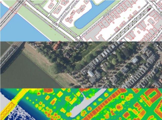
Figure BGT map data (top) and airborne sensor data (middle: 2D aerial image, bottom: 3D lidar point cloud)
Meet the team