4. Modelling erosion from pyroclastic flow deposits on Mount Pinatubo
This exercise deals with the evaluation of erosion from pyroclastic flow deposits on Mount Pinatubo, Philippines. The Pinatubo volcano erupted in 1991 and produced an enormous deposit of hot ashes, up to 200 meters thick. In the years after the eruption, heavy rainfall in the area triggered large erosion and lead to a series of lahars. The main objective of this exercise is to evaluate the rapidly changing geomorphology in the upper Sacobia catchment before and during the eruption, and for three consecutive years afterward.
Introduction and background information
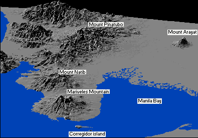 Mount Pinatubo is situated on the island of Luzon, about 80 km northeast of Manila, the capital of the Philippines. The volcano, with K-Ar datings of approximately 1.1 million years, and with youngest C14 dating of ±400 years BP, is the youngest volcano in the Zambales range and in the western Luzon volcanic arc. The figure at the right gives a three dimensional overview of the region around Mount Pinatubo.
The 1991 eruption deposited about 6.83 km³ of pyroclastic flows into different watersheds. The Sacobia watershed, which is the watershed analyzed in this exercise, starts at the eastern crater rim of the volcano and extends downslope until reaching the lowland Candaba swamp (50 km east) and Manila bay (60 km southeast).
The rapid erosion or removal of the 1991 pyroclastic flow deposit is one of the major social and scientific concerns after the 1991 eruption of the Pinatubo Volcano as life threatening and destructive lahars of enormous magnitude are generated. About 50,000 persons were left homeless by the lahars and the indirect impacts such as flooding and isolation have affected more than 1.3 million people in 39 different towns and 4 large cities. About 1000 km² of prime agricultural lands are at risk. Lahars predominantly occur during the rainy season in the southwest monsoon period, which lasts from June till November. The average annual rainfall varies from 1946 mm east of Pinatubo to 3900 mm in the west. Long duration and high intensity, which is responsible for the production of large magnitude of destructive lahars, is usually associated with the occurrence of strong typhoons.
Methodology
In order to evaluate the geomorphologic changes in the upper Sacobia catchment, the following activities were undertaken:
- Elaboration of geomorphologic maps for the pre- and post-eruption situations, up till 1993. This was done in order to evaluate the changes in the catchment areas and their significance in producing lahars.
- Creation of digital terrain models for each year, from which the thickness of pyroclastic flows, and the yearly eroded volume can be calculated.
To calculate the volume of the 1991 pyroclastic flow deposits and the yearly eroded sediment volumes, a DTM overlaying technique using GIS was applied. For this procedure it was necessary to constuct DTMs of several periods:
- the pre-eruption DTM
- the post-plinian eruption DTM which shows the undisturbed deposits of the 1991 pyroclastic flows a post-lahar 1991 DTM
- a post-lahar 1992 DTM
- a post-lahar 1993 DTM
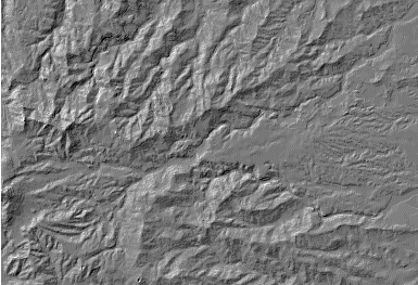
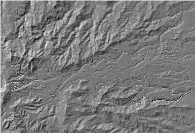
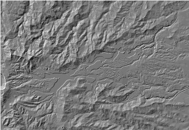
Another way to visually compare these five different situations is to generate a so-called hill-shading image from each DTM. A hill-shading image simulates the shadows created by the sun from NE. Slopes directed to the northeast are shown in bright gray, and slopes directed to the southwest in dark gray.
| |
Pre-eruption DTM | |
|
|
post-plinian eruption DTM | post-lahar 1991 DTM |
|
|
post-lahar 1992 DTM | post-lahar 1993 DTM |


Calculation of the thickness and volume of pyroclastic deposits
First the changes in the catchment sizes are calculated that are the result of the accumulation of the pyroclastic flow deposits. These changes can be calculated by crossing the raster maps of the catchments before and after the eruption. With a simple TabCalc formula you can convert the output values of the cross table to square kilometers. Once you know the changes in catchment areas, you can look at the thickness and volume of pyroclastic flow material. The thickness of the deposits can be calculated by subtracting post-eruption DTM from the pre-eruption DTM with the following MapCalc formula: pfthick = iff(dtmerp-dtmpre>0,dtmerp-dtmpre,0). To calculate the volume of pyroclastic flow deposits, cross the post-eruption map with the just created thickness map. Then multiply the Area column with the Thickness column in the cross table to get the volume of pyroclastic flow deposits for each thickness. With an aggregation function the total volume in million cubic meters is calculated.
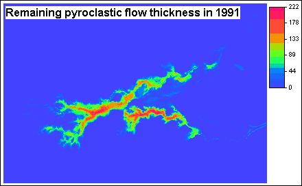
Calculation of erosion and sedimentation after the three rainy seasons
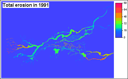
Now that you know the thickness and the amount of pyroclastic flow deposits you can calculate the changes in these thicknesses and volumes after each rainy season. For each period you have to calculate:
- the changes in catchment areas,
- the thickness and volume of eroded materials,
- the thickness and volume of eroded pyroclastic flow deposits
- the thickness and volume of erosion in other deposits
- the thickness and volume of sedimentation
- the remaining pyroclastic flow materials after the lahar
You can use a schematic cross-section showing the situation in order to design your MapCalc formulas. For example, for the situation after the first rainy season of 1991, you should cross the raster maps of the catchments to get the changes in catchment areas and use the following formulas to get thickness maps of:
- all eroded material: Ero91=iff(Dtm91<dtmerp,dtmerp-dtm91,0)
- erosion in pyroclastic flow deposits: Eropf91=iff((ero91>0)and(dtm91>dtmpre),dtmerp-dtm91, iff((ero91>0)and(dtm91<dtmpre),dtmerp-dtmpre,0))
- erosion in other deposits: Eroot91=iff((Ero91>0)and(Dtm91<dtmpre),dtmpre-dtm91,0)
- sedimentation: Sed91=iff(Dtm91>Dtmerp,Dtm91-Dtmerp,0)
- remaining pyroclastic flow material: Pfth91=iff(Dtm91>Dtmerp,Dtmerp-Dtmpre, iff(Dtm91<dtmpre,0,dtm91-dtmpre))
The next step is to calculate catchment volumes. To do that, you should cross the thickness maps with the catchment map. With some TabCalc formulas and aggregation functions you can finally calculate the total volumes. You should follow the same procedure for the situations after the 1992 and 1993 rainy seasons, each time subtracting the newly eroded areas from the DTM of the preceding year.
References
Daag, A. and Van Westen, C.J. (1996). Cartographic modelling of erosion in pyroclastic flow deposits of Mount Pinatubo, Philippines. ITC Journal 1996-2: 110-124.
Pierson, T.C., Janda, R.J., Umbal, J.V. and Daag, A.S. (1992). Immediate and Long Term Hazards from Lahars and Excess Sedimentation in Rivers Draining Mt. Pinatubo, Philippines. United States Geological Water Survey Resources Investigation Report 92-4039. USGS Vancouber, Washington, 35pp.
Punongbayan, R.S., Tungol, N.M., Arboleda, R.A., DelosReyes, P.J., Isada, M., Martinez, M.L., Melosantos, M.L.P., Puertollano, J., Regalado, T.M., Solidum, R.U., Tubianosa, B.S., Umbal, J.V., Alfonso, R.A. and Remotique, C.T. (1993). Impacts of the 1993 Lahars and Long-Term Lahar hazards and Risks Around Pinatubo Volcano. Philippine Institute of Volcanology and Seismology (PHIVOLCS). PHIVOLCS publication, Quezon City, 72 pp.
For more information on this case study, contact:
C.J. van Westen
Department of Earth Systems Analysis,
International Institute for Geo-Information Science and Earth Observation (ITC),
P.O. Box 6, 7500 AA Enschede, The Netherlands.
Tel: +31 53 4 874 263, Fax: +31 53 4 874 336, e-mail: westen@itc.nl