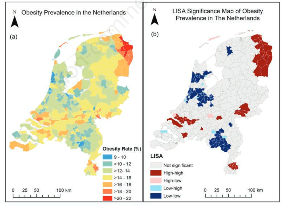
Obesity has nearly tripled since the 1970s worldwide. Understanding the drivers of the spatial distribution of obese hotspots is important for developing strategic intervention programmes. Here we use a variety of geographic data to better understand the spatial distribution of obesity.
Related courses
View all programmesGeo-Health - 7EC (online course)
Geohealth integrates spatial analysis methods and concepts with epidemiology to provide students with skills to address a variety of health and disease analyses.Certificate10 weeksFull-time100% EnglishGeo-information Science and Earth Observation
Are you interested in a career in GIS/spatial data science and becoming a geospatial professional?8 SpecialisationsMaster of Science2 yearsFull-time100% English4 Joint programmesApplied Remote Sensing for Earth Sciences
In this specialisation, you will Iearn how use remote sensing and geographic information systems (GIS) to map supplies of critical raw materials and geothermal resources.MSc2 Joint programmesGeo-Information Management for Land Administration
How can you develop responsible land administration systems? In this specialisation, you will develop cadastral maps, land registries, and other land records to help people secure their land tenure.MSc2 Joint programmesGeoinformatics
How can you process massive geospatial data into actionable insights? This specialisation teaches you to construct algorithmic solutions and other AI methods to address real-life geospatial problems.MSc3 Joint programmesNatural Hazards and Disaster Risk Reduction
Learn how to use geo-information to predict, monitor, and quantify hazards and their magnitude in a specific geographic area and time and to design geospatial risk reduction approaches.MSc2 Joint programmesNatural Resources Management
Learn to utilize geo-spatial data for sustainable agriculture, environement and forests.MSc3 Joint programmesUrban Planning and Management
How to transform cities into healthier, more sustainable, and inclusive places where people and nature can thrive? Learn to understand complex urban processes and develop sustainable strategies.MSc2 Joint programmesWater Resources and Environmental Management
Learn to apply geo-information and Earth observation techniques to tackle global water-related challenges such as flooding, water scarcity, water pollution, and food safety.MSc2 Joint programmes