Gain working knowledge and experience with geological remote sensing data, software, and methods.
On 30 September 2023, University of Twente | ITC, organises a workshop during the 29th Colloquium of African Geology 2023 (CAG23), in Windhoek, Namibia.
The workshop Geological Remote Sensing: data, methods and Techniques, open to all CAG23 participants, is developed and led by applied and research earth scientists with decades of experience in various geological remote sensing techniques.
The workshop introduces the theory and data used in applying geological remote sensing, with a practical step-by-step exercise utilising multivariate remotely sensed datasets. The workshop exercises aim to leverage freely-available software and data where possible. This is an ideal opportunity to gain working knowledge and experience with geological remote sensing data, software, and methods.
Register
The number of places is limited, so please register as soon as possible.
Flyer
Course developers
Applied and research earth scientists of the Department of Applied Earth Sciences of the Faculty of Geo-information Science and Earth Observation (ITC) | University of Twente.
- Bruno Virgilio Portela
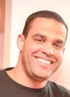 Mr Portela is a geologic remote sensing and mineral spectroscopy lecturer and Course Director at the Department of Applied Earth Sciences at the Faculty ITC of the University of Twente. Bruno is a geologist with a master's degree in applied remote sensing with solid international mining and research experience. Bruno has completed the BHP Billiton Foundations for Graduate Program and was involved in several processes within the short-term planning area and technology projects at Escondida Mine, the world's largest copper mine.
 - Chris Hecker
 Dr Hecker is an Associate Professor in geologic and thermal infrared sensing at the Department of Applied Earth Sciences at the Faculty ITC of the University of Twente, where he combines his background in earth sciences with remote sensing and GIS. Chris is a remote sensing geologist driven to turn cutting-edge research in thermal and hyperspectral remote sensing into best practices and fit-for-purpose solutions. In addition, he has experience leading multi-disciplinary and multi-cultural research teams, where data sharing and cross-discipline.
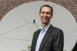
 - Harald van der Werff
 Dr van der Werff is an Associate Professor in geological remote sensing at the University of Twente, The Netherlands. He teaches MSc and PhD courses on remote sensing, data processing and computer programming and has broad experience in international training and capacity building. His research is reflected in more than 150 scientific publications on earth science applications of remote sensing. Specifically, these are the chemical characterisation of the earth's surface, porting hyperspectral technology to free satellite imagery, analysis of multi-temporal satellite imagery and time-lapse camera data for monitoring earth dynamics.
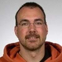
 - Mark van der Meijde
 Prof. Dr. van der Meijde has an MSc in earth sciences from Utrecht University (1998) and a PhD in geophysics from ETH Zurich, Switzerland (2003). In the past, prof. Dr. van der Meijde worked at the Dutch Seismological Institute (KNMI) and the Dutch geological survey (NITG-TNO). Prof. Dr. van der Meijde started in 2003 ITC's department of Earth Systems Analysis. Prof. Dr. van der Meijde is now the head of the Applied Earth Sciences (ITC-AES) department and professor in Geophysics, focusing on imaging of Earth structure, composition, and dynamics through a better understanding of the use of earth observation data. In particular, the focus is on the structure and deformation of the earth due to natural processes and the added value of satellite-borne geophysical sensors in it.
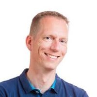
 - Andries Botha
 Mr Botha is an applied earth sciences practitioner focusing on the geological sciences. His experience includes using geological, remote sensing and geospatial software & data to create products for strategic decision-making in the exploration, mining, engineering, and agricultural sectors. With a strong private sector background, he now focuses on bridging the gap between academia and the private sector to facilitate improved adaptation of advanced remote sensing methodologies and technologies.


