Funded by NWO PIPP (Partnerships for space Instruments & Applications Preparatory Programme) (May 2020 – April 2024)
Project Objectives
- Establish and maintain a long-term collaborative network of knowledge institutes and commercial entities involved in the use of microwave remote sensing of vegetation for agriculture and food security.
- Inventory new opportunities for vegetation monitoring from candidate missions (e.g. CIMR, ROSE-L, Harmony, HydroTerra), and provide a roadmap towards their exploitation in key applications related to agriculture and food security.
Research Contents
Monitoring and modeling of vegetation in the natural environment needs to consider several challenges in estimating the scattering and emission properties of the vegetated land surfaces. When only a bare soil surface is considered, the dominant factors that determine the scattering and emission signatures are soil surface roughness and the dynamic soil moisture and soil temperature profiles. For a vegetated land surface, the vegetation itself also causes scattering and emission signatures, in addition to its attenuation of the signatures from the underlying soil surface. The presence of the vegetation complicates both components by the interactions of the signals in the vegetation-soil system but also provides the needed signature for monitoring vegetation. The key challenge for remote sensing of vegetation is to be able to describe and separate the contributions of the different components in the observed total signature of the vegetated lands.
In the MINERVA project, we intend to systematically study and contribute to understanding the precise scattering-emission mechanism of vegetated lands. We will focus on following three activities:
- Assembling in-situ observation of scattering-emission of vegetated surfaces to develop a multi-frequency simulator for synthesizing data from future microwave missions.
- Integrated modeling of MW scattering-emission and optical-thermal (MV-OPT-TIR) signatures. The optimally combined optical and microwave data is expected to be used to retrieve bio-geophysical variables and information at the scales required by users.
- Application of the MW-OPT-TIR model for understanding the functioning of agroecosystems.
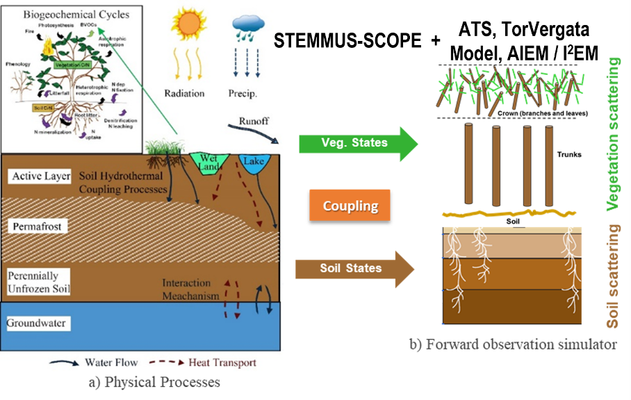
Figure 1 STEMMUS-SCOPE model (for understanding soil-water-plant-energy interactions) will be coupled to air-to-soil transition model, discrete scattering model (TorVergata), as well as the advanced integral equation model (AIEM/I2EM). The development of such multi-frequency (MV-OPT-TIR) forward observation simulator will contribute to the development of Community Land Active Passive Microwave Radiative Transfer Modelling Platform (CLAP)
Partners